Sumenep (town)
Kota Sumenep
| |
|---|---|
| Kota Sumenep District Kecamatan Kota Sumenep | |
| Madurese transcription(s) | |
| • Latèn script | Kottha Songennep |
| • Pèghun script | كَوڟّا سَوڠۤنّۤڤ |
| • Carakan script | ꦏꦺꦴꦛ꧀ꦛꦯꦺꦴꦔꦼꦤ꧀ꦤꦼꦥ꧀ |
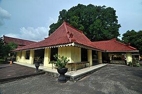
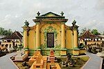
Asta Tinggi Cemetery Sumenep Museum Taman Sare Water Castle Bull Racing in Giling Stadium | |
| Nicknames: | |
| Motto(s): Songennep ta’ Abingker (unofficial) (Madurese for "Frameless Sumenep") Word meaning: "Sumenepese are Wanderer" | |
| Coordinates: 7°00′05″S 113°52′11″E / 7.001328818787373°S 113.869682245928°E | |
| Country | |
| Province | |
| Regency | |
| Capital | Pamolokan |
| Subdivisions | 16 villages |
| Government | |
| • Head of district | Yudi Nursukmadyanto |
| • District secretary | Parman |
| • Head of government section | R.A Tayyibah |
| • General subdivision | Mohammad Aprilla |
| Area | |
• Total | 27.84 km2 (10.75 sq mi) |
| • Rank | 26th in Sumenep |
| Elevation | 10 m (30 ft) |
| Highest elevation (Kebunagung Hill) | 30 m (100 ft) |
| Lowest elevation (Marengan River) | 0 m (0 ft) |
| Population (end 2023 estimate)[1] | |
• Total | 75,367 |
| • Rank | 2nd in Sumenep |
| • Density | 2,707/km2 (7,010/sq mi) |
| • Rank | 1st in Sumenep |
| Demonym(s) | Sumenepese (en) Sumenepan (id) Sumenebhân (mad) |
| Demographics | |
| • Ethnic groups[2] | |
| • Religion[3] |
|
| • Languages |
|
| Time zone | UTC+7 (IWST) |
| Postal code | 69412 – 69417 |
| Area code | (+62) 328 |
| Vehicle registration | M xxxx U*/V*/W*/X*/Y*/Z* |
| Abbreviation[4] | SMP |
| Airport (main airport) | Trunojoyo Airport |
| Bus station (main bus station) | Arya Wiraraja bus station |
| Largest villages or wards by area | Pabian – 4.95 square kilometres (1.91 sq mi) |
| Largest villages or wards by population | Kolor (16,262 – 2023 est) |
| Website | kec-kota |
| Other transcription(s) | |||||||||||||||||||||||||||||||||||||||||||||||||||||||||||||||||||||||||||||||||
|---|---|---|---|---|---|---|---|---|---|---|---|---|---|---|---|---|---|---|---|---|---|---|---|---|---|---|---|---|---|---|---|---|---|---|---|---|---|---|---|---|---|---|---|---|---|---|---|---|---|---|---|---|---|---|---|---|---|---|---|---|---|---|---|---|---|---|---|---|---|---|---|---|---|---|---|---|---|---|---|---|---|
| Chinese name | |||||||||||||||||||||||||||||||||||||||||||||||||||||||||||||||||||||||||||||||||
| Traditional Chinese | 哥打蘇民納 | ||||||||||||||||||||||||||||||||||||||||||||||||||||||||||||||||||||||||||||||||
| Simplified Chinese | 哥打苏民纳 | ||||||||||||||||||||||||||||||||||||||||||||||||||||||||||||||||||||||||||||||||
| Postal | Kota Soominna | ||||||||||||||||||||||||||||||||||||||||||||||||||||||||||||||||||||||||||||||||
| Literal meaning | from Kota Sumenep, a phrase that means "Settled Water Town" | ||||||||||||||||||||||||||||||||||||||||||||||||||||||||||||||||||||||||||||||||
| |||||||||||||||||||||||||||||||||||||||||||||||||||||||||||||||||||||||||||||||||
| Alternative Chinese name | |||||||||||||||||||||||||||||||||||||||||||||||||||||||||||||||||||||||||||||||||
| Chinese | 漯水市 | ||||||||||||||||||||||||||||||||||||||||||||||||||||||||||||||||||||||||||||||||
| Postal | Loshui Shih | ||||||||||||||||||||||||||||||||||||||||||||||||||||||||||||||||||||||||||||||||
| Literal meaning | "Lowland River Town" | ||||||||||||||||||||||||||||||||||||||||||||||||||||||||||||||||||||||||||||||||
| |||||||||||||||||||||||||||||||||||||||||||||||||||||||||||||||||||||||||||||||||
| Arabic name | |||||||||||||||||||||||||||||||||||||||||||||||||||||||||||||||||||||||||||||||||
| Arabic |
| ||||||||||||||||||||||||||||||||||||||||||||||||||||||||||||||||||||||||||||||||
| Javanese name | |||||||||||||||||||||||||||||||||||||||||||||||||||||||||||||||||||||||||||||||||
| Javanese |
| ||||||||||||||||||||||||||||||||||||||||||||||||||||||||||||||||||||||||||||||||
| Dutch name | |||||||||||||||||||||||||||||||||||||||||||||||||||||||||||||||||||||||||||||||||
| Dutch |
| ||||||||||||||||||||||||||||||||||||||||||||||||||||||||||||||||||||||||||||||||
| Japanese name | |||||||||||||||||||||||||||||||||||||||||||||||||||||||||||||||||||||||||||||||||
| Japanese |
| ||||||||||||||||||||||||||||||||||||||||||||||||||||||||||||||||||||||||||||||||
Kota Sumenep,[a] officially the Kota Sumenep District,[b] is a town and district which serves as the regency seat of Sumenep Regency, East Java, Indonesia. It is the second smallest and populated district in Sumenep Regency, with an area of 27.84 square kilometres (10.75 sq mi) and the population of 75,367 as of 2023.[1] The administrative capital is Pamolokan. On 29 June 2004, part of the Kota Sumenep District was expanded into a separate district, namely Batuan District.
This district is located 175 km east of Surabaya and 965 km east of Jakarta. Geographically, Kota Sumenep is in the eastern coast of Madura island. Infrastructure and settlements from Sumenep Regency are also concentrated in this district, which is the center of government and economy for regency at the far eastern end of the island of Madura. Hugely prosperous in the eighteenth century, it is now a quiet, peaceful backwater, with its past glory still in evidence.
Etymology
[edit]Kota Sumenep gained it is name from the combination of two words. The word Kota comes from Indonesian word kota which in turn comes from the Sanskrit word कोट्ट (koṭṭa) which means fort, fortress, castle, fortified house, fortification, works, city, town, or place encircled by walls.[5] It is also used formally in a few other Indonesian towns (districts) and cities, for example; Kota Jantho, Kota Tambolaka, and Kota Waisai. It can also be used informally to refer to any towns (districts) or cities. Hence, a direct translation of the name Kota Sumenep into English would be "Town of Sumenep" or "Sumenep Town".
While the name Sumenep originated from the language of Old Javanese people from the words of Sungeneb (Kawi: ᬲᬸᬗᭂᬦᭂᬩ᭄, romanized: Suṅĕnĕb) which means "the quiet valley", referring to most of the Kota Sumenep area which used to be land used by swamp deposits. Hence, Western writers often refer to Sumenep as Soemanap, Samanap or Soemenep. In Bijdragen tot de kennis van de residentie Madoera (1858) published in Tijdschrift voor Nederlandsch Indië, J. Hageman stated that since Tirtonegoro replaced Cokronegoro II in 1751, the word Sumenep was used officially as meaning "settled water" – bezonken water (in Dutch).
Geography
[edit]Most of the Kota Sumenep District area is located in the lowlands, which around 46 percent is paddy fields, rivers and plantations, the remainder is in the form of residential land, offices or agencies, shops, industry and other urban infrastructure. It is bordered by the Manding District to the north, Gapura District with Kalianget District to the east, and the Batuan District to the south and west.[6]
Climate
[edit]Sumenep has a tropical savanna climate (Aw) with May to November and heavy rainfall from December to April.
| Climate data for Sumenep | |||||||||||||
|---|---|---|---|---|---|---|---|---|---|---|---|---|---|
| Month | Jan | Feb | Mar | Apr | May | Jun | Jul | Aug | Sep | Oct | Nov | Dec | Year |
| Mean daily maximum °C (°F) | 30.7 (87.3) |
30.9 (87.6) |
31.1 (88.0) |
31.8 (89.2) |
31.7 (89.1) |
31.3 (88.3) |
31.1 (88.0) |
31.4 (88.5) |
32.1 (89.8) |
32.7 (90.9) |
32.7 (90.9) |
31.5 (88.7) |
31.6 (88.9) |
| Daily mean °C (°F) | 26.4 (79.5) |
26.6 (79.9) |
26.9 (80.4) |
27.4 (81.3) |
27.3 (81.1) |
26.8 (80.2) |
26.5 (79.7) |
26.6 (79.9) |
27.1 (80.8) |
27.8 (82.0) |
27.8 (82.0) |
27.1 (80.8) |
27.0 (80.6) |
| Mean daily minimum °C (°F) | 22.2 (72.0) |
22.4 (72.3) |
22.7 (72.9) |
23.0 (73.4) |
22.9 (73.2) |
22.4 (72.3) |
21.9 (71.4) |
21.8 (71.2) |
22.2 (72.0) |
22.9 (73.2) |
23.0 (73.4) |
22.7 (72.9) |
22.5 (72.5) |
| Average rainfall mm (inches) | 275 (10.8) |
246 (9.7) |
244 (9.6) |
168 (6.6) |
122 (4.8) |
74 (2.9) |
37 (1.5) |
8 (0.3) |
7 (0.3) |
37 (1.5) |
112 (4.4) |
237 (9.3) |
1,567 (61.7) |
| Source: Climate-Data.org[7] | |||||||||||||
Government
[edit]Kota Sumenep is led by a head of district who is then assisted by a district secretary or secretariat in carrying out his duties. The current head of the Kota Sumenep District is Yudi Nursukmadyanto, who has served since 2024 and is assisted by a district secretary named Parman.[8]
Administrative divisions
[edit]Administratively, the Kota Sumenep District area has 12 villages (desa) and 4 urban villages/wards (kelurahan) which are divided into 57 hamlets (dusun) or neighborhoods (lingkungan). The following is a list of names of the villages (desa and kelurahan) located in Kota Sumenep District:[9]
| Name Village or Ward | Area in km2 |
Pop'n estimate 2021 |
Number of hamlets |
Postal code | Ministry of Affairs code |
|---|---|---|---|---|---|
| Kolor | 3.24 | 12,845 | 5 | 69417 | 35.29.01.2005 |
| Pabian | 4.95 | 6,468 | 4 | 69417 | 35.29.01.2006 |
| Marengan Daya | 0.95 | 2,251 | 4 | 69417 | 35.29.01.2007 |
| Kacongan | 2.24 | 2,173 | 4 | 69417 | 35.29.01.2008 |
| Paberasan | 4.09 | 4,283 | 4 | 69417 | 35.29.01.2009 |
| Parsanga | 3.18 | 5,047 | 3 | 69417 | 35.29.01.2010 |
| Bangkal | 0.41 | 2,348 | 3 | 69417 | 35.29.01.2011 |
| Pangarangan | 0.53 | 5,297 | 3 | 69412 | 35.29.01.2014 |
| Kepanjin* | 0.33 | 3,200 | 4 | 69415 | 35.29.01.2015 |
| Pajagalan* | 0.65 | 3,926 | 2 | 69416 | 35.29.01.2016 |
| Bangselok* | 0.43 | 4,972 | 4 | 69416 | 35.29.01.2017 |
| Karangduak* | 0.30 | 3,724 | 4 | 69417 | 35.29.01.2018 |
| Pandian | 0.73 | 4,418 | 3 | 69414 | 35.29.01.2019 |
| Pamolokan** | 1.74 | 7,934 | 4 | 69412 | 35.29.01.2013 |
| Kebunan | 1.54 | 3,130 | 3 | 69417 | 35.29.01.2012 |
| Kebunagung | 2.52 | 2,773 | 3 | 69413 | 35.29.01.2020 |
Note: (*) urban village/ward (kelurahan).
(**) administrative capital.
Notes
[edit]- ^
- English: /ˈkoʊtə ˈsuːməˌnɛp/ KOH-tuh SOO-muh-nep
- Indonesian pronunciation: [ˈkota suˈmǝ.nǝp̚]
- Madurese: Kottha Songennep, pronounced [ˈkɔʈːa sɔˈŋǝnːǝp̚]
- ^
- Indonesian: Kecamatan Kota Sumenep
- Madurese: Kacamadhân Kottha Songennep
References
[edit]- ^ a b Badan Pusat Statistik, Jakarta, 28 February 2024, Kabupaten Sumenep Dalam Angka 2024 (Katalog-BPS 1102001.3529)
- ^ Indonesia's Population: Ethnicity and Religion in a Changing Political Landscape. Institute of Southeast Asian Studies. 2003.
- ^ "Jumlah Penduduk Menurut Kecamatan dan Agama yang Dianut di Kabupaten Sumenep 2022 (Population by Districts and Religions in Sumenep Regency 2022)" (PDF) (in Indonesian). Retrieved 5 December 2024.
- ^ "Singkatan Nama Kota (Abbreviation of City Names)" (PDF) (in Indonesian). p. 8. Retrieved 5 December 2024.
- ^ Siegel, James T. (2018). Southeast Asia over Three Generations: Essays Presented to Benedict R. O'G. Anderson. New York: Cornell University Press. p. 94. ISBN 9781501718946.
- ^ Badan Pusat Statistik (2020). Kecamatan Kota Sumenep Dalam Angka 2020 (Kota Sumenep District in Figures 2020). Sumenep: Badan Pusat Statistik.
- ^ "Climate: Sumenep". Climate-Data.org. Retrieved 15 November 2020.
- ^ "Perjanjian Kinerja Perubahan Tahun 2024, Kecamatan Kota Sumenep (Changed Performance Agreement in 2024, Kota Sumenep District)" (PDF) (in Indonesian). Retrieved 5 December 2024.
- ^ Badan Pusat Statistik (2022). Kecamatan Kota Sumenep Dalam Angka 2022 (Kota Sumenep District in Figures 2022). Sumenep: Badan Pusat Statistik.
This article needs additional citations for verification. (January 2021) |


