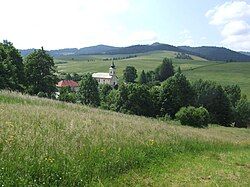
Stráňany
Stráňany | |
|---|---|
Village | |
 | |
| Coordinates: 49°22′N 20°32′E / 49.367°N 20.533°E | |
| Country | |
| Region | Prešov |
| District | Stará Ľubovňa |
| First mentioned | 1343 |
| Area | |
• Total | 11.60[2] km2 (4.48[2] sq mi) |
| Elevation | 640[3] m (2,100[3] ft) |
| Population (2021) | |
• Total | 179[1] |
| Area code | +421 52[3] |
| Website | http://www.stranany.sk/ |
Stráňany (until 1948: Folvark; Hungarian: Nagymajor; Polish: Folwark; Rusyn: Страняны) is a village and municipality in Stará Ľubovňa District in the Prešov Region of northern Slovakia. The village is traditionally inhabited by Rusyns, as one of their westernmost settlements. There is Greek Catholic church built in 1857.
History
[edit]In historical records the village was first mentioned in 1343. Initially it was a hamlet of Veľký Lipník with a folvark (hence the name prior to 1948). Around 1567 Vlachs settled here, who would later become Rusyns.[5] Before the establishment of independent Czechoslovakia in 1918, Folwark was part of Szepes County within the Kingdom of Hungary. From 1939 to 1945, it was part of the Slovak Republic. On 25 January 1945, the Red Army dislodged the Wehrmacht from Folwark and it was once again part of Czechoslovakia.
Geography
[edit]The municipality lies at an altitude of 650 metres and covers an area of 11.607 km2. It has a population of about 194 people.
Notable people
[edit]References
[edit]- ^ "Počet obyvateľov podľa pohlavia - obce (ročne)". www.statistics.sk (in Slovak). Statistical Office of the Slovak Republic. 2022-03-31. Retrieved 2022-03-31.
- ^ a b "Hustota obyvateľstva - obce [om7014rr_ukaz: Rozloha (Štvorcový meter)]". www.statistics.sk (in Slovak). Statistical Office of the Slovak Republic. 2022-03-31. Retrieved 2022-03-31.
- ^ a b c d "Základná charakteristika". www.statistics.sk (in Slovak). Statistical Office of the Slovak Republic. 2015-04-17. Retrieved 2022-03-31.
- ^ a b "Hustota obyvateľstva - obce". www.statistics.sk (in Slovak). Statistical Office of the Slovak Republic. 2022-03-31. Retrieved 2022-03-31.
- ^ Józef Nyka (2010). Pieniny. Przewodnik. Latchorzew. p. 60. ISBN 978-83-60078-09-9.
{{cite book}}: CS1 maint: location missing publisher (link)


