Saint-Ouen-l'Aumône
Appearance
(Redirected from Saint-Ouen-l'Aumone)
Saint-Ouen-l'Aumône | |
|---|---|
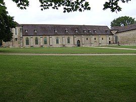
 Maubuisson Abbey | |
| Coordinates: 49°02′41″N 2°06′40″E / 49.0447°N 2.1111°E | |
| Country | France |
| Region | Île-de-France |
| Department | Val-d'Oise |
| Arrondissement | Pontoise |
| Canton | Saint-Ouen-l'Aumône |
| Intercommunality | Cergy-Pontoise |
| Government | |
| • Mayor (2020–2026) | Laurent Linquette[1] |
Area 1 | 12.21 km2 (4.71 sq mi) |
| Population (2021)[2] | 25,023 |
| • Density | 2,000/km2 (5,300/sq mi) |
| Time zone | UTC+01:00 (CET) |
| • Summer (DST) | UTC+02:00 (CEST) |
| INSEE/Postal code | 95572 /95310 |
| Elevation | 22–58 m (72–190 ft) |
| 1 French Land Register data, which excludes lakes, ponds, glaciers > 1 km2 (0.386 sq mi or 247 acres) and river estuaries. | |
Saint-Ouen-l'Aumône (French pronunciation: [sɛ̃t‿wɛ̃ lomon] ) is a commune in the northwestern suburbs of Paris, France. It is located 27.6 km (17.1 mi) from the center of Paris, in the "new town" of Cergy-Pontoise, created in the 1960s.
Population
[edit]
|
| ||||||||||||||||||||||||||||||||||||||||||||||||||||||||||||||||||||||||||||||||||||||||||||||||||||||||||||||||||
| |||||||||||||||||||||||||||||||||||||||||||||||||||||||||||||||||||||||||||||||||||||||||||||||||||||||||||||||||||
| Source: EHESS[3] and INSEE (1968-2017)[4] | |||||||||||||||||||||||||||||||||||||||||||||||||||||||||||||||||||||||||||||||||||||||||||||||||||||||||||||||||||
Transport
[edit]Saint-Ouen-l'Aumône is served by two interchange stations on Paris RER C line and on the Transilien Paris-Nord suburban rail line: Saint-Ouen-l'Aumône-Liesse and Saint-Ouen-l'Aumône.
Saint-Ouen-l'Aumône is also served by two other stations on the Transilien Paris-Nord suburban rail line: Épluches and Pont-Petit.
Finally, Saint-Ouen-l'Aumône is also served by Saint-Ouen-l'Aumône-Quartier de l'Église station on the Transilien Paris-Saint-Lazare suburban rail line.
Education
[edit]Schools in the commune include:
- Four sets of preschools (maternelles) and elementary schools: Matisse, Prairie, Jean Effel, Le Nôtre[5]
- One combined preschool and elementary school, Ecole Prévert[5]
- Three primary school groups: De Liesse, Des Borseaux, and Jean-Jacques Rousseau[5]
- Two junior high schools: Collège et SEGPA Marcel Pagnol and Collège Le Parc[6]
- Three senior high schools: Lycée polyvalent Edmond Rostand, Lycée technique Jean Perrin, and Lycée des métiers de l’automobile et du transport du Château d’Épluches[6]
See also
[edit]References
[edit]- ^ "Répertoire national des élus: les maires". data.gouv.fr, Plateforme ouverte des données publiques françaises (in French). 2 December 2020.
- ^ "Populations légales 2021" (in French). The National Institute of Statistics and Economic Studies. 28 December 2023.
- ^ Des villages de Cassini aux communes d'aujourd'hui: Commune data sheet Saint-Ouen-l'Aumône, EHESS (in French).
- ^ Population en historique depuis 1968, INSEE
- ^ a b c "Les établissements d'enseignement primaire." Saint-Ouen-l'Aumône. Retrieved on September 6, 2016.[dead link]
- ^ a b "Collèges, lycées." Saint-Ouen-l'Aumône. Retrieved on September 6, 2016.
External links
[edit]Wikimedia Commons has media related to Saint-Ouen-l'Aumône.
- Official website (in French)
- Base Mérimée: Search for heritage in the commune, Ministère français de la Culture. (in French)
- Association of Mayors of the Val d'Oise (in French)


