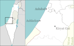
Revaha
Appearance
Revaha
רווחה رفاحا | |
|---|---|
 | |
| Coordinates: 31°38′56″N 34°43′59″E / 31.64889°N 34.73306°E | |
| Country | Israel |
| District | Southern |
| Council | Shafir |
| Affiliation | Hapoel HaMizrachi |
| Founded | 1953 |
| Founded by | Kurdish immigrants |
| Population (2022)[1] | 573 |
Revaha (Hebrew: רְוָחָה, lit. prosperity) is a religious moshav in south-central Israel. Located in the southern Shephelah near Kiryat Gat, it falls under the jurisdiction of Shafir Regional Council. In 2022 it had a population of 573.[1]
History
[edit]Revaha was established in 1953 by Jewish immigrants from Kurdistan on lands which had formerly belonged to the depopulated Palestinian village of Karatiyya.[2] It is located close to Hatta, but not on its village land.[3]
The majority of residents are national-religious. [citation needed]
References
[edit]Wikimedia Commons has media related to Revaha.
- ^ a b "Regional Statistics". Israel Central Bureau of Statistics. Retrieved 21 March 2024.
- ^ Khalidi, Walid (1992). All That Remains: The Palestinian Villages Occupied and Depopulated by Israel in 1948. Washington D.C.: Institute for Palestine Studies. p. 119. ISBN 0-88728-224-5. ISBN 0-88728-224-5.
- ^ Khalidi, Walid (1992). All That Remains: The Palestinian Villages Occupied and Depopulated by Israel in 1948. Washington D.C.: Institute for Palestine Studies. p. 101. ISBN 0-88728-224-5. ISBN 0-88728-224-5.

