Preiļi District
Appearance
(Redirected from Preili District)
This article needs additional citations for verification. (May 2013) |
Preiļi | |
|---|---|
District | |
 | |
| Country | Latvia |
| Area | |
• Total | 2,042 km2 (788 sq mi) |
| Population | |
• Total | 37,743 |
| • Density | 18/km2 (48/sq mi) |
| Website | preilirp.lv |
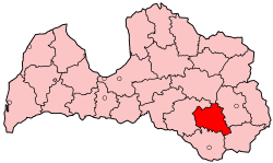
Preiļi District (Latvian: Preiļu rajons) was an administrative division of Latvia, located in Latgale region, in the country's east. It bordered the former districts of Jēkabpils, Madona, Rēzekne, Krāslava and Daugavpils.
Districts were eliminated during the administrative-territorial reform in 2009.
References
[edit]- ^ "RESIDENT POPULATION BY REGION, CITY AND DISTRICT AT THE BEGINNING OF THE YEAR". Centrālās statistikas pārvaldes datu bāzes. Archived from the original on 10 January 2009. Retrieved 23 January 2009.
56°18′N 26°43′E / 56.300°N 26.717°E
