Buk District, Ulsan
Buk
북구 | |
|---|---|
| Korean transcription(s) | |
| • Hanja | 北區 |
| • Revised Romanization | Buk-gu |
| • McCune–Reischauer | Puk-ku |
 | |
| Country | South Korea |
| Region | Yeongnam |
| Provincial level | Ulsan |
| Administrative divisions | 27 administrative dong |
| Government | |
| • Mayor | Park Cheon-dong (People Power) |
| Area | |
• Total | 80.41 km2 (31.05 sq mi) |
| Population (2024[1]) | |
• Total | 216,561 |
| • Density | 2,700/km2 (7,000/sq mi) |
| • Dialect | Gyeongsang |
| Website | Buk District Office |

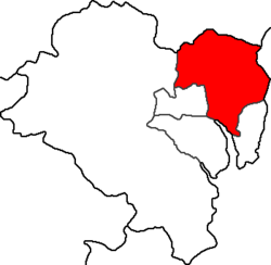
Buk District (Korean: 북구; RR: Buk-gu; lit. north district) is a gu, or district, in north central Ulsan, South Korea. It stretches roughly from the Ring Road to Mohwa into the north and out to the coast in the east.
Demographics
[edit]149,676 people live in Buk-gu's 80.41 km2. 77,214 of these are Korean males, 71,183 are Korean females, 961 are foreign males and 318 are foreign females (2006). In no dong do women outnumber men.
Administrative divisions
[edit]The dong of Buk-gu are:
- Changpyeong-dong (Korean: 창평동)
- Cheongok-dong (Korean: 천곡동)
- Daean-dong (Korean: 대안동)
- Dalcheon-dong (Korean: 달천동)
- Dangsa-dong (Korean: 당사동)
- Eomul-dong (Korean: 어물동)
- Gadae-dong (Korean: 가대동)
- Guyu-dong (Korean: 구유동)
- Hogye-dong (Korean: 호계동)
- Hwabong-dong (Korean: 화봉동)
- Hyomun-dong (Korean: 효문동)
- Jeongja-dong (Korean: 정자동)
- Jinjang-dong (Korean: 진장동)
- Jungsan-dong (Korean: 중산동)
- Maegok-dong (Korean: 매곡동)
- Muryong-dong (Korean: 무룡동)
- Myeongchon-dong (Korean: 명촌동)
- Sanha-dong (Korean: 산하동)
- Sinhyeon-dong (Korean: 신현동)
- Sinjeon-dong (Korean: 신전동)
- Sinmyeong-dong (Korean: 신명동)
- Sangan-dong (Korean: 상안동)
- Sirae-dong (Korean: 시래동)
- Songjeong-dong (Korean: 송정동)
- Yangjeong-dong (Korean: 양정동)
- Yeompo-dong (Korean: 염포동)
- Yeonam-dong (Korean: 연암동)
Local attractions
[edit]- Jeongja Beach (정자 해수욕장)
Jeongja Beach (정자 해수욕장) is the most popular in Ulsan and there are several raw fish restaurants and pleasant western restaurants-come-bars lining the coast road around here. Most people in Ulsan go here infrequently, however, as it lies at the other end of a twisted road over the hills just south of Muryongsan (무룡산), Ulsan's second-highest hill.
- Jujeon Mongdol beach (주전몽돌해변)
Jujeon Mongdol beach (주전몽돌해변) is a beach that connects Jujeon (주전) and Gangdong (강동) and its length is about 1.5 km. It was also selected as one of the "12 must-see natural sights of Ulsan2 by Ulsan Metropolitan Government. Different from most beaches that are covered with sand, Junjeon Mongdol beach is covered with smooth pebble stones. Especially the seaside course that connects Jujeon (주전)-Jengja (정자)-Gangdong (강동) is well known for the best drive course of Ulsan.
Education
[edit]High school
[edit]- Dalcheon High School
- Maegok High School
- Ulsan Dongcheon High School
- Ulsan Sports Science High School
- Ulsan Foreign Language High School
- Ulsan Energy High School
- ULSAN HOGYE HIGHSCHOOL
- Hwabong High School
- Hyojung High School
Middle school
[edit]- Kangdong Middle School
- Goheon Middle School
- Nongso Middle School
- Dalchun Middle School
- Maegok Middle School
- Sangan Middle School
- Yeonam Middle School
- Ulsan Sports Science Middle School
- Ehwa Middle School
- Cheongok Middle School
- Hogye Middle School
- Hyojung Middle school
Transport
[edit]Transport in Buk-gu is simple, as most of the population are in striking distance of either the Ring Road or National Road 7, which is the main road up the East Coast of South Korea and which, at this point, connects Ulsan with Gyeongju to the north. Ulsan's domestic airport (IATA Code: USN), which serves Seoul is located in Buk-gu.[2]
Port and Fishing Harbor Status in Buk District
[edit]- National Fishing Harbor: Jeongja Harbor
- Local Fishing Harbor: Dangsa Harbor
- Fishing Villages (Resident Fishing Harbors): Gumbaou Harbor, Sinmyeong Harbor, Eomul Harbor, Jejeon Harbor
- Small-Scale Fishing Harbors: Uga Harbor, Upper Uga Harbor, Panji Harbor, Hwaam Harbor
Sister cities
[edit]See also
[edit]List of districts in South Korea Buk-gu, Ulsan (South Korea electorate)
References
[edit]- ^ "Population statistics". Korea Ministry of the Interior and Safety. 2024.
- ^ "Introduction of Ulsan Airport". Archived from the original on September 29, 2007. Retrieved 2008-05-27.
- ^ "Sister Cities of Buk-gu". Ulsan Buk-gu. Archived from the original on 2016-01-12. Retrieved 2008-05-28.
External links
[edit]- Everything you need to know about Ulsan (in English)
- Official site (in Korean)
- Official site (in English)
35°34′53″N 129°21′40″E / 35.58139°N 129.36111°E
- ^ "RFC 3.0 오류 메세지".
- ^ 000102003000000&orderBy=DATA_TITLE:ASC&startPage=1&categoryCode1=C003&dataSid=119
- ^ "울산 12경".
- ^ "주전해변".
- ^ "주전 몽돌해안과 봉수대".

