Natanebi
Appearance
(Redirected from Natanebi River)
| Natanebi | |
|---|---|
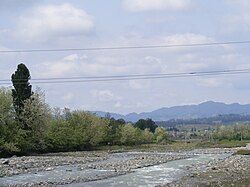
 The Natanebi near Tskhemliskhidi | |
 | |
| Native name | ნატანები (Georgian) |
| Location | |
| Country | Georgia |
| Physical characteristics | |
| Mouth | Black Sea |
• location | Shekvetili |
• coordinates | 41°54′50″N 41°46′01″E / 41.9140°N 41.7670°E |
| Length | 60 km (37 mi) |
| Basin size | 657 km (408 mi) |
| Basin features | |
| Tributaries | |
| • left | Choloki |
The Natanebi (Georgian: ნატანები) is a river in western Georgia, located in the region of Guria. It flows into the Black Sea near Shekvetili. It is 60 km (37 mi) long, and has a drainage basin of 657 km2 (254 sq mi).[1][2]
The Natanebi corresponds to the ancient River Isis, described by Greek historian Arrian of Nicomedia in his Periplus of the Euxine Sea.[3]
References
[edit]- ^ Statistical Yearbook of Georgia: 2020, National Statistics Office of Georgia, Tbilisi, 2020, p. 12.
- ^ Georgian Soviet Encyclopedia Vol. 7, p. 327, 1984.
- ^ Arrian, William Falconer, and Thomas Falconer. Arrian's Voyage Round the Euxine Sea Translated; And Accompanied with a Geographical Dissertation, and Maps. Oxford: J. Cook, 1805.
