Murovdağ
| Murovdağ / Mrav | |
|---|---|
 | |
| Highest point | |
| Peak | Gamish Mountain |
| Elevation | 3,724 m (12,218 ft) |
| Dimensions | |
| Length | 70 km (43 mi) |
| Geography | |
| Country | Azerbaijan |
| Range coordinates | 40°16′00″N 46°19′00″E / 40.2667°N 46.3167°E |
| Parent range | Armenian Highlands |
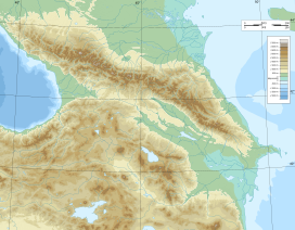
The Murovdağ or Mrav (Azerbaijani: Murovdağ, ; Armenian: Մռավի լեռնաշղթա, romanized: Mr’avi Ler’nashght’a)[1][2] is the highest mountain range in the Lesser Caucasus. The range is about 70 kilometres (43 mi) long, and Gamish Mountain is its highest peak at 3,724 metres (12,218 ft). It is made up mainly of Jurassic, Cretaceous and Paleogene rocks.[3]
The Murovdağ ridge or Mrav range extends north from Hinaldag Peak through Gamish (or Gomshasar) Mountain. Geographically, it is a continuation of the Sevan mountains to the west.[4] The northeastern slope features a group of scenic lakes, including Göygöl near the northern slope. The Karabakh Plateau extends from the south of Murovdağ/Mrav. Fir and spruce forests are spread as far southeast as the Murovdağ. The summer mountain pastures of Murovdağ/Mrav were traditionally used by Azerbaijani and Armenian shepherds.
Name
[edit]According to Armenian linguist Hrachia Acharian, the name Mrav derives from the Armenian word mar’ 'darkness, fog' and means 'foggy'.[5]
History
[edit]Following the First Nagorno-Karabakh War, the mountain ridge formed the northern part of the line of contact separating the self-proclaimed Republic of Artsakh from Azerbaijan. Its southern slopes ran through the Martakert region of Nagorno-Karabakh.[1] In late 1993–early 1994, the ridge was the scene of the bloodiest battle of the First Nagorno-Karabakh War that ended in an Armenian victory.[6]
During the 2020 Nagorno-Karabakh war, the peak of Murovdag came under Azerbaijani control.[7][8][9]
Gallery
[edit]-
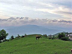
View from Nagorno-Karabakh, village of Vaghuhas
References
[edit]- ^ a b DeRouen, Karl R.; Heo, Uk (2007). Civil Wars of the World: Major Conflicts since World War II. Santa Barbara: ABC-Clio. p. 105. ISBN 978-1-85109-919-1.
- ^ "Nagorno-Karabakh Republic: Geographical location". Ministry of Foreign Affairs of the Nagorno Karabakh Republic. Archived from the original on 18 February 2012. Retrieved 7 February 2012.
- ^ Azerbaijan Soviet Encyclopedia (1983), vol. 7, p. 93
- ^ "Mṛavi leṛnashghtʻa" Մռավի լեռնաշղթա [Mrav mountain range]. Hayastani bnashkharh Հայաստանի բնաշխարհ [Encyclopedia of Armenian Nature]. Yerevan: Armenian Encyclopedia Publishing House. 2006. p. 38.
- ^ Acharian, Hrachia (1946). "Mṛaw" Մռաւ. Hayotsʻ andznanunneri baṛaran Հայոց անձնանունների բառարան [Dictionary of Armenian given names] (in Armenian). Vol. 3. Yerevan: Petakan hamalsarani hratarakchʻutʻyun. pp. 473.
- ^ Abbasov, Idrak (21 February 2004). "Azeri Veterans Recall Military Fiasco". Institute for War and Peace Reporting. Archived from the original on 16 June 2022. Retrieved 18 March 2023.
- ^ "Azerbaijan Captures 'Strategic' Mountain After Clashes with Armenia, 5 Killed in Fighting". news18.com. 27 September 2020. Retrieved 18 March 2023.
- ^ "Clashes Between Azerbaijan and Armenia Separatists Leave at Least 23 Dead". The Moscow Times. 27 September 2020.
- ^ "Men flock to military recruitment centers in Azerbaijan during a partial mobilisation". uk.news.yahoo.com. AFP UK. 29 September 2020. Archived from the original on 30 October 2020.
External links
[edit] Media related to Murovdagh at Wikimedia Commons


