Mealhada
Mealhada | |
|---|---|
 | |
 | |
| Coordinates: 40°23′N 8°27′W / 40.383°N 8.450°W | |
| Country | |
| Region | Centro |
| Intermunic. comm. | Região de Coimbra |
| District | Aveiro |
| Parishes | 6 |
| Government | |
| • President | Rui Marqueiro (PS) |
| Area | |
• Total | 110.66 km2 (42.73 sq mi) |
| Population (2011) | |
• Total | 20,428 |
| • Density | 180/km2 (480/sq mi) |
| Time zone | UTC+00:00 (WET) |
| • Summer (DST) | UTC+01:00 (WEST) |
| Local holiday | Ascension Day date varies |
| Website | http://www.cm-mealhada.pt |
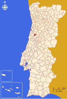
Mealhada (Portuguese pronunciation: [mi.ɐˈʎaðɐ] ⓘ) is a city and a municipality located in Aveiro District in Portugal. The population in 2011 was 20,428,[1] in an area of 110.66 km2.[2] It had 17,043 eligible voters (2006). The city of Mealhada itself has a population of 4,522.[3]
It is included in the Região de Coimbra. The city of Coimbra is about 20 km away.
The current mayor is Rui Marqueiro, elected by the Socialist Party. The municipal holiday is Ascension Day.
Demographics
[edit]| Population of Mealhada's Municipality (1801–2011) | |||||||||
|---|---|---|---|---|---|---|---|---|---|
| 1801 | 1849 | 1900 | 1930 | 1960 | 1981 | 1991 | 2001 | 2004 | 2011 |
| 2326 | 7102 | 9915 | 13869 | 17478 | 19305 | 18272 | 20751 | 21500 | 20428 |
Parishes
[edit]Administratively, the municipality is divided into 6 civil parishes (freguesias):[4]
- Barcouço
- Casal Comba
- Luso
- Mealhada, Ventosa do Bairro e Antes
- Pampilhosa
- Vacariça
Cities and towns
[edit]- Mealhada (city) / [cidade] .
- Towns: Luso; Pampilhosa
Villages
[edit](Partial list):
Attractions
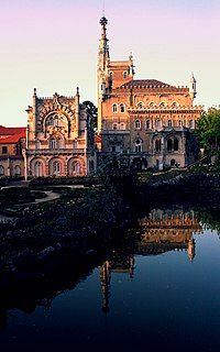
[edit]The Buçaco Palace (Portuguese: Palácio Hotel do Buçaco) is a luxury hotel in the Luso parish, in the municipality of Mealhada, in the Serra do Buçaco mountains. Other interesting sights near Luso: Cruz Alta, a dense wooded forest.
Other attractions: Mealhada: City Park (Parque da Cidade de Mealhada).
Principal train stations
[edit]The most important train stations are: Pampilhosa, Mealhada and Luso.
References
[edit]- ^ Instituto Nacional de Estatística
- ^ "Áreas das freguesias, concelhos, distritos e país". Archived from the original on 29 July 2018. Retrieved 5 November 2018.
- ^ [1] Census 2011 (INE - Statistics Portugal)
- ^ Diário da República. "Law nr. 11-A/2013, page 552 69" (PDF) (in Portuguese). Retrieved 28 July 2014.
External links
[edit]


