Ariège (river)
Appearance
(Redirected from L'Ariège)
| Ariège | |
|---|---|
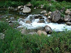
 The Ariège near Ax-les-Thermes | |
 | |
| Location | |
| Countries | |
| Physical characteristics | |
| Source | |
| • location | Pyrenees |
| • elevation | ± 2,400 m (7,900 ft) |
| Mouth | |
• location | Garonne |
• coordinates | 43°31′2″N 1°24′36″E / 43.51722°N 1.41000°E |
| Length | 163 km (101 mi) |
| Basin size | 3,860 km2 (1,490 sq mi) |
| Discharge | |
| • average | 65 m3/s (2,300 cu ft/s) |
| Basin features | |
| Progression | Garonne→ Gironde estuary→ Atlantic Ocean |
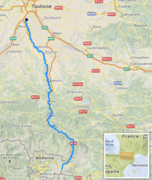
The Ariège (French pronunciation: [aʁjɛʒ] ⓘ; Occitan: Arièja; Catalan: Arieja) is a river in southern France, a right tributary of the Garonne.[1] From its source in the Pyrenees near El Pas de la Casa, the river flows north, forming part of the border with Andorra, and passing through the following towns in two departments:
- In Ariège: Ax-les-Thermes, Les Cabannes, Tarascon-sur-Ariège, Montgailhard, Foix, Varilhes, Pamiers, Saverdun.
- In Haute-Garonne: Cintegabelle, Auterive, Pinsaguel.
Its longest tributaries are the Hers-Vif and the Lèze. It flows into the Garonne in Portet-sur-Garonne, south of Toulouse.[1] Taken literally, the Latin origin of the river's name, Aurigera, indicates it to be a source of gold.
References
[edit]External links
[edit]Wikimedia Commons has media related to Ariège River.
Categories:
- Tributaries of the Garonne
- Rivers of France
- Rivers of Andorra
- International rivers of Europe
- Rivers of Ariège (department)
- Rivers of Haute-Garonne
- Andorra–France border
- Rivers of Occitania (administrative region)
- Border rivers
- Occitania (administrative region) geography stubs
- France river stubs
- Europe river stubs
- Andorra geography stubs
