Kosum Phisai district
Appearance
(Redirected from Kosum Phisai District)
This article needs additional citations for verification. (November 2015) |
Kosum Phisai
โกสุมพิสัย | |
|---|---|
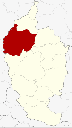
 District location in Maha Sarakham province | |
| Coordinates: 16°14′55″N 103°4′1″E / 16.24861°N 103.06694°E | |
| Country | Thailand |
| Province | Maha Sarakham |
| Area | |
• Total | 827.876 km2 (319.645 sq mi) |
| Population (2014) | |
• Total | 120,584 |
| • Density | 143.9/km2 (373/sq mi) |
| Time zone | UTC+7 (ICT) |
| Postal code | 44140 |
| Geocode | 4403 |
Kosum Phisai (Thai: โกสุมพิสัย, pronounced [kōː.sǔm pʰí.sǎj]) is a district (amphoe) in the northern part of Maha Sarakham province, northeastern Thailand.
Geography
[edit]Neighboring districts are (from the north clockwise): Chiang Yuen, Kantharawichai, Mueang Maha Sarakham, Borabue, and Kut Rang of Maha Sarakham Province: Ban Phai, Ban Haet, and Mueang Khon Kaen of Khon Kaen province.
Administration
[edit]Central administration
[edit]Kosum Phisai is divided into 17 sub-districts (tambons), which are further subdivided into 235 administrative villages (mubans).
| No. | Name | Thai | Villages | Pop.[1] |
|---|---|---|---|---|
| 1. | Hua Khwang | หัวขวาง | 24 | 18,078 |
| 2. | Yang Noi | ยางน้อย | 14 | 6,373 |
| 3. | Wang Yao | วังยาว | 12 | 6,153 |
| 4. | Khwao Rai | เขวาไร่ | 20 | 11,007 |
| 5. | Phaeng | แพง | 16 | 9,195 |
| 6. | Kaeng Kae | แก้งแก | 10 | 4,318 |
| 7. | Nong Lek | หนองเหล็ก | 20 | 9,780 |
| 8. | Nong Bua | หนองบัว | 12 | 6,156 |
| 9. | Lao | เหล่า | 11 | 4,474 |
| 10. | Khuean | เขื่อน | 11 | 5,627 |
| 11. | Nong Bon | หนองบอน | 11 | 5,934 |
| 12. | Phon Ngam | โพนงาม | 12 | 6,749 |
| 13. | Yang Tha Chaeng | ยางท่าแจ้ง | 10 | 4,800 |
| 14. | Hae Tai | แห่ใต้ | 19 | 6,437 |
| 15. | Nong Kung Sawan | หนองกุงสวรรค์ | 10 | 5,432 |
| 16. | Loeng Tai | เลิงใต้ | 12 | 3,975 |
| 17. | Don Klang | ดอนกลาง | 11 | 6,096 |
Local administration
[edit]There is one sub-district municipality (thesaban tambon) in the district:
- Kosum Phisai (Thai: เทศบาลตำบลโกสุมพิสัย) consisting of parts of sub-district Hua Khwang.
There are 17 sub-district administrative organizations (SAO) in the district:
- Hua Khwang (Thai: องค์การบริหารส่วนตำบลหัวขวาง) consisting of parts of sub-district Hua Khwang.
- Yang Noi (Thai: องค์การบริหารส่วนตำบลยางน้อย) consisting of sub-district Yang Noi.
- Wang Yao (Thai: องค์การบริหารส่วนตำบลวังยาว) consisting of sub-district Wang Yao.
- Khwao Rai (Thai: องค์การบริหารส่วนตำบลเขวาไร่) consisting of sub-district Khwao Rai.
- Phaeng (Thai: องค์การบริหารส่วนตำบลแพง) consisting of sub-district Phaeng.
- Kaeng Kae (Thai: องค์การบริหารส่วนตำบลแก้งแก) consisting of sub-district Kaeng Kae.
- Nong Lek (Thai: องค์การบริหารส่วนตำบลหนองเหล็ก) consisting of sub-district Nong Lek.
- Nong Bua (Thai: องค์การบริหารส่วนตำบลหนองบัว) consisting of sub-district Nong Bua.
- Lao (Thai: องค์การบริหารส่วนตำบลเหล่า) consisting of sub-district Lao.
- Khuean (Thai: องค์การบริหารส่วนตำบลเขื่อน) consisting of sub-district Khuean.
- Nong Bon (Thai: องค์การบริหารส่วนตำบลหนองบอน) consisting of sub-district Nong Bon.
- Phon Ngam (Thai: องค์การบริหารส่วนตำบลโพนงาม) consisting of sub-district Phon Ngam.
- Yang Tha Chaeng (Thai: องค์การบริหารส่วนตำบลยางท่าแจ้ง) consisting of sub-district Yang Tha Chaeng.
- Hae Tai (Thai: องค์การบริหารส่วนตำบลแห่ใต้) consisting of sub-district Hae Tai.
- Nong Kung Sawan (Thai: องค์การบริหารส่วนตำบลหนองกุงสวรรค์) consisting of sub-district Nong Kung Sawan.
- Loeng Tai (Thai: องค์การบริหารส่วนตำบลเลิงใต้) consisting of sub-district Loeng Tai.
- Don Klang (Thai: องค์การบริหารส่วนตำบลดอนกลาง) consisting of sub-district Don Klang.
References
[edit]- ^ "Population statistics 2014" (in Thai). Department of Provincial Administration. Retrieved 2015-03-06.
External links
[edit]Wikimedia Commons has media related to Kosum Phisai District.
