Kishtwar
Kishtwar | |
|---|---|
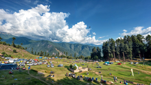
 View of Chowgan Ground in Kishtwar town, Jammu and Kashmir, India | |
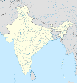
| Coordinates: 33°19′N 75°46′E / 33.32°N 75.77°E | |
| Country | |
| Union Territory | Jammu & Kashmir |
| Division | Jammu |
| District | Kishtwar |
| Government | |
| • Type | Municipal Committee |
| • Body | Kishtwar Municipal Committee |
| Area | |
• Total | 22.5 km2 (8.7 sq mi) |
| Elevation | 1,638 m (5,374 ft) |
| Population (2011) | |
• Total | 14,865 |
| • Density | 660/km2 (1,700/sq mi) |
| Languages | |
| • Official | Kashmiri, Hindi, Urdu, Dogri, English[1][2] |
| • Spoken | Kashmiri, Kishtwari, Urdu, Hindi |
| Time zone | UTC+5:30 (IST) |
| PIN | 182204 |
| Vehicle registration | JK17 |
| Website | www |
Kishtwar is a town, municipality and administrative headquarter of the Kishtwar district in the Indian-administered Jammu and Kashmir.[3] The district was carved out of the Doda district in 2007.[4] and is located in the Jammu division. The town of Kishtwar is situated at a distance of 209.5 km (130.2 mi) from the summer capital of Srinagar, and 211.5 km (131.4 mi) from the winter capital of Jammu. A large ground locally called as Chowgan ground is located in the heart of the town.[5]
In 2013, the municipality was the location of the Kishtwar Riots, which claimed three lives and injured 80 more,[6][7] and was a conflict between Muslim and Hindu communities that occurred in the aftermath of the Eid festival on 9 August 2013 at Kishtwar, Jammu and Kashmir.
Demographics
[edit]As of the 2011 Indian census, Kishtwar had a population of 14,865. Males constitute 63% of the population and females 37%. Kishtwar has an average literacy rate of 78%, higher than the Indian national average: male literacy is 82%, and female literacy is 42%. In Kishtwar, 11% of the population is under six years of age. The main language spoken here by Muslims is Kashmiri and Kishtwari, while the Hindus of Kishtwar speak a dialect of Kashmiri language called Kishtwari.[9] The dominant religion in Kishtwar is Islam, at 70.3% of the population, while there are 28.6% followers of Hinduism.[8]
Transport
[edit]Air
[edit]Kishtwar does not have its own airport as 2023, although there is a helipad located just 3 km north of the city. The government has a project for a 1200–1300 airstrip in Kishtwar in upcoming years.[10][11] The nearest airports to Kishtwar is Srinagar International Airport located 208.8km away.
Rail
[edit]There is no rail-connectivity to Kishtwar yet. The nearest railway station is Udhampur railway station, located at a distance of 150 kilometres.
Road
[edit]Kishtwar is well-connected by roads to other places in Jammu and Kashmir and rest of India, as several highways and roads pass through Kishtwar including NH 244.
See also
[edit]
References
[edit]- ^ "The Jammu and Kashmir Official Languages Act, 2020" (PDF). The Gazette of India. 27 September 2020. Retrieved 27 September 2020.
- ^ "Parliament passes JK Official Languages Bill, 2020". Rising Kashmir. 23 September 2020. Archived from the original on 24 September 2020. Retrieved 23 September 2020.
- ^ "District Kishtwar".
- ^ "History - Kishtwar". Retrieved 22 October 2021.
- ^ "Chowgan | District Kishtwar, Government of Jammu & Kashmir | India".
- ^ Ahmed Ali Fayyaz (11 June 2013). "Curfew imposed in Rajouri; Jaitley may be sent back from airport". The Hindu. Retrieved 13 August 2013.
- ^ Ahmed Ali Fayyaz (9 August 2013). "Kishtwar clashes: Top cops removed". The Hindu. Retrieved 13 August 2013.
- ^ a b "Kishtwar City Population". Census India. Retrieved 11 July 2021.
- ^ Kashmiri, Ethnologue, retrieved 14 July 2018.
- ^ "Construction works of airstrip at Kishtwar to begin soon". The Dispatch. 30 May 2020. Archived from the original on 24 September 2020. Retrieved 2 June 2020.
- ^ "Kishtwar in J&K to get full-fledged Airport". Press Information Bureau (Govt. of India). Retrieved 16 January 2018.


