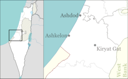
Kiryat Malakhi
Kiryat Malachi
קִרְיַת מַלְאָכִי, קִרְיַת מַלְאָכִי | |
|---|---|
City (from 1998) | |
| Hebrew transcription(s) | |
| • ISO 259 | Qiryat Malˀaki |
| • Also spelled | Kiryat Malachi (official) Qiryat Mal'akhi (unofficial) |
Images of Kiryat Malakhi | |
| Coordinates: 31°43′45″N 34°44′46″E / 31.72917°N 34.74611°E | |
| Country | |
| District | Southern |
| Founded | 1951 |
| Government | |
| • Mayor | Eliyahu "Lalo" Zohar |
| Area | |
• Total | 4,632 dunams (4.632 km2 or 1.788 sq mi) |
| Population (2022)[1] | |
• Total | 25,705 |
| • Density | 5,500/km2 (14,000/sq mi) |
| Ethnicity | |
| • Jews and others | 99.6% |
| • Arabs | 0.4% |
| Name meaning | City of Angels |


Kiryat Malachi (Hebrew: קריית מלאכי,[2] also spelled Kiryat Malahi, Kiryat Malakhi, or Qiryat Mal'akhi) is a city in the Southern District of Israel, 17 kilometres (11 mi) from the city of Ashkelon. In 2022 it had a population of 25,705.[1] Its jurisdiction is 4,632 dunams (~4.6 km2).
History
[edit]
Qastina
[edit]Before the establishment of Kiryat Malachi, the Palestinian village of Qastina stood at this location. Qastina's population in 1945 was 890, and its economy was largely agricultural, with its people growing citrus groves and cereals. Furthermore, an elementary school for boys was established in Qastina in 1936, and by 1945 had an enrollment of 145 students. Students from the nearby Palestinian village of Tall al-Turmus also used to attend this school. Qastina also had one mosque.[3][4]
During the 1948 Arab-Israeli War, on July 9th, 1948, Qastina was assaulted by the Giv'ati Brigade. Today, only debris remains where the village once stood.[3][4][5]
Establishment of Kiryat Malachi
[edit]Kiryat Malachi, literally "City of Angels" in Hebrew, was established in 1951 as a ma'abara (lit. 'temporary residential'), to house the masses of Jewish settlers who have arrived during the early years of the newly established State of Israel, many of them part of the Jewish exodus from Arab and Muslim countries. The name was chosen to honor the Jewish community of Los Angeles, which contributed much of the funding for its establishment.[6] It has been one of several development towns of the Negev, at that time being.[citation needed]
Moshe Katsav, later Israel's 8th president, was elected mayor in 1969, at the age of 24. His younger brother Lior Katsav has also been a mayor of Kiryat Malachi; whilst Yosef Vanunu held the post from 1981 until the 1990s. The current mayor is Eliyahu "Lalo" Zohar.[7]
On 15 November 2012 missile attacks were launched by Palestinian militant groups from the Gaza Strip as a response to Israel's Operation Pillar of Defense. These attacks resulted in the deaths of three residents of the city.[8]
Demographics
[edit]
The arrival of new immigrants from the former Soviet Union as well as from Ethiopia in a few previous decades, has increased the population of Kiryat Malachi by 40 percent. Some 22,000 people now reside in the city.[9] In January 2012, Israeli television publicized a case of a seller in the municipality creating a restrictive covenant barring the sale or lease of property to Ethiopian Jews. The case led to public outcry and demonstrations of hundreds of people, and caused the Association for Civil Rights in Israel to call on the Registrar of Real Estate to revoke the licence of real estate agents who practice such discrimination.[10]
Sports
[edit]There is a 1,000-seat football (soccer) stadium named Teddy Arena, being held as the home-grounds for the local association club of Maccabi Kiryat Malachi.
Transportation
[edit]
The city's main transportation hub is the Malachi Junction (also known as Qastina).
Education
[edit]According to CBS, there are 15 schools and 4,909 students in the city. They are spread out as 10 elementary schools and 2,867 elementary school students, and 2 high schools and 2,042 high school students.[citation needed]
Twin towns – sister cities
[edit]Kiryat Malachi is twinned with:
References
[edit]- ^ a b c "Regional Statistics". Israel Central Bureau of Statistics. Retrieved 21 March 2024.
- ^ https://k-m.org.il [bare URL]
- ^ a b "Welcome to Qastina- قسطينة (קסטינה)". Palestine Remembered.
- ^ a b "Depopulated Villages Qastina Governed by Gaza | Depopulated Palestinian villages | Our Palestine". فلسطيننا. 24 June 2023. Retrieved 24 August 2024.
- ^ "Remembering-Qastina – Vermonters for Justice in Palestine". Retrieved 24 August 2024.
- ^ Derfner, Larry (19 October 2006). "The Boy Next Door". The Jerusalem Post. Retrieved 20 October 2008.
- ^ "KKL-JNF Celebrates World Environment Day". Jewish National Fund. Archived from the original on 1 July 2007. Retrieved 20 October 2008.
- ^ "3 Israeli Civilians Killed in Gaza Rocket Attack on Kiryat Malachi, Baby Critically Injured (GRAPHIC PHOTOS)".
- ^ "Overseas Supplemental Giving/IEF". United Jewish Communities. Archived from the original on 21 May 2007. Retrieved 20 October 2008.
- ^ Fein, Leonard (29 January 2012). "Echoes of U.S. Racism in Israel". Forward.
- ^ "Orașe Înfrățite" (in Romanian). Piatra Neamț. Retrieved 25 March 2022.
- ^ "Piatra Neamţ - Twin Towns". © 2007-2008 piatra-neamt.net. Archived from the original on 16 November 2009. Retrieved 27 September 2009.
- ^ "Villes jumelles". villederueil.fr (in French). Rueil-Malmaison. Retrieved 20 November 2019.
- ^ https://www.villederueil.fr/fr/kiryat-malakhi-israel [bare URL]
- ^ 格尔木市戮力打造丝路开放新高地. Haixi Prefecture Science and Technology Bureau. 11 April 2017. Retrieved 26 July 2018.
External links
[edit]![]() Media related to Kiryat Malakhi at Wikimedia Commons
Media related to Kiryat Malakhi at Wikimedia Commons
- Official website (in Hebrew)


