Khai Bang Rachan district
Khai Bang Rachan
ค่ายบางระจัน | |
|---|---|
 Monument of Bang Rachan Heroes | |
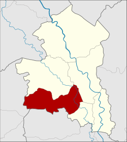
 District location in Sing Buri province | |
| Coordinates: 14°48′1″N 100°18′39″E / 14.80028°N 100.31083°E | |
| Country | Thailand |
| Province | Sing Buri |
| Seat | Bang Rachan |
| Tambon | 6 |
| Muban | 59 |
| District established | 1972 |
| Area | |
• Total | 88.398 km2 (34.131 sq mi) |
| Population (2014) | |
• Total | 28,316 |
| • Density | 319.7/km2 (828/sq mi) |
| Time zone | UTC+7 (ICT) |
| Postal code | 16150 |
| Geocode | 1703 |
Khai Bang Rachan (Thai: ค่ายบางระจัน, pronounced [kʰâːj bāːŋ rā.t͡ɕān]) is a district (amphoe) of Sing Buri province, central Thailand.
History
[edit]In 1966 the government renovated Khai Bang Rachan (Camp Bang Rachan). They agreed to establish a new district to commemorate the battle at Bang Rachan. The area was thus separated from Bang Rachan district and became a minor district (king amphoe) on 1 February 1972, then consisting of five sub-districts.[1] It was upgraded to a full district in 1976.[2] The sixth sub-district, Nong Krathum, was created in 1980.[3]
Geography
[edit]Neighboring districts are (from the north clockwise): Bang Rachan, Mueang Sing Buri and Tha Chang of Sing Buri Province, Sawaeng Ha of Ang Thong province, and Doem Bang Nang Buat of Suphanburi province.
Administration
[edit]Central administration
[edit]Khai Bang Rachan is divided into six sub-districts (tambons), which are further subdivided into 59 administrative villages (mubans).
| No. | Name | Thai | Villages | Pop.[4] |
|---|---|---|---|---|
| 1. | Pho Thale | โพทะเล | 8 | 4,661 |
| 2. | Bang Rachan | บางระจัน | 11 | 7,382 |
| 3. | Pho Sangkho | โพสังโฆ | 14 | 6,756 |
| 4. | Tha Kham | ท่าข้าม | 14 | 4,472 |
| 5. | Kho Sai | คอทราย | 6 | 2,526 |
| 6. | Nong Krathum | หนองกระทุ่ม | 6 | 2,519 |
Local administration
[edit]There is one sub-district municipality (thesaban tambon) in the district:
- Pho Sangkho (Thai: เทศบาลตำบลโพสังโฆ) consisting of parts of sub-district Pho Sangkho.
There are six sub-district administrative organizations (SAO) in the district:
- Pho Thale (Thai: องค์การบริหารส่วนตำบลโพทะเล) consisting of sub-district Pho Thale.
- Khai Bang Rachan (Thai: องค์การบริหารส่วนตำบลค่ายบางระจัน) consisting of sub-district Bang Rachan.
- Pho Sangkho (Thai: องค์การบริหารส่วนตำบลโพสังโฆ) consisting of parts of sub-district Pho Sangkho.
- Tha Kham (Thai: องค์การบริหารส่วนตำบลท่าข้าม) consisting of sub-district Tha Kham.
- Kho Sai (Thai: องค์การบริหารส่วนตำบลคอทราย) consisting of sub-district Kho Sai.
- Nong Krathum (Thai: องค์การบริหารส่วนตำบลหนองกระทุ่ม) consisting of sub-district Nong Krathum.
References
[edit]- ^ ประกาศกระทรวงมหาดไทย เรื่อง แบ่งท้องที่อำเภอบางระจัน ตั้งเป็นกิ่งอำเภอค่ายบางระจัน จังหวัดสิงห์บุรี (PDF). Royal Gazette (in Thai). 89 (17 ง): 178. February 1, 1972. Archived from the original (PDF) on May 24, 2012.
- ^ พระราชกฤษฎีกาตั้งอำเภอเลาขวัญ อำเภอคำม่วง อำเภอพิปูน อำเภอศรีเทพ อำเภอนาแห้ว อำเภอส่องดาว อำเภอควนกาหลง อำเภอค่ายบางระจัน อำเภอบ้านตาขุน และอำเภอกุดจับ พ.ศ. ๒๕๑๙ (PDF). Royal Gazette (in Thai). 93 (109 ก ฉบับพิเศษ): 31–34. September 8, 1976. Archived from the original (PDF) on September 27, 2007.
- ^ ประกาศกระทรวงมหาดไทย เรื่อง ตั้งและเปลี่ยนแปลงเขตตำบลในท้องที่อำเภอค่ายบางระจัน จังหวัดสิงห์บุรี (PDF). Royal Gazette (in Thai). 97 (127 ง): 2811. August 19, 1980. Archived from the original (PDF) on May 24, 2012.
- ^ "Population statistics 2014" (in Thai). Department of Provincial Administration. Retrieved 2015-10-13.
External links
[edit]- amphoe.com (Thai)
