Kayamkulam
Kayamkulam | |
|---|---|
Azheekal Bridge Krishnapuram Palace | |
| Coordinates: 9°10′19″N 76°30′04″E / 9.172°N 76.501°E | |
| Country | |
| State | Kerala |
| District | Alappuzha |
| Government | |
| • Body | Kayamkulam Municipality |
| • MLA | U Prathiba |
| Area | |
• Total | 21.79 km2 (8.41 sq mi) |
| Population (2011)[2] | |
• Total | 68,634 |
| • Density | 3,100/km2 (8,200/sq mi) |
| Languages | |
| • Official | Malayalam, English |
| Time zone | UTC+5:30 (IST) |
| PIN | 690502 |
| Telephone code | +91-479 |
| Vehicle registration | KL-29 |
| Nearest city | Kollam (38 km), Alappuzha (46 km) |
| Sex ratio | 0.944 ♂/♀ |
| Literacy | 81.76% |
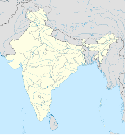
Kayamkulam (IPA: [ka:yəmˠkuɭam]) is a municipality[3] in the Alappuzha district of Kerala, India. It is located 46 km (28.6 mi) south of the district headquarters in Alappuzha and about 110 km (68.4 mi) north of the state capital Thiruvananthapuram. As per the 2011 Indian census, Kayamkulam has a population of 68,634 people, and a population density of 3,149/km2 (8,160/sq mi).
Kayamkulam was the erstwhile capital of the Kingdom of Onattukara, and today continues to be the largest town in the Onattukara region.

History
[edit]Kayamkulam was a medieval feudal kingdom known as Odanad ruled by the Kayamkulam rajas. Maha Raja Marthanda Varma (1706–58) conquered Kayamkulam and annexed its territories to Travancore.
Tourist attractions
[edit]The Krishnapuram Palace, built in the 18th century, now functions as a museum. Constructed in typical Keralan-style architecture, it has the largest mural painting in Kerala.[4] The palace museum houses the Kayamkulam double-edged sword.[5]
The Kayamkulam Boat Race[6] is held on the fourth Saturday of August every year.[7] Chinese fishing nets can be found on the banks of the lagoon. Veliyaazheekal is a beach at Arattupuzha panchayat in Kayamkulam.The main attraction in this place bow string arch Bridge (biggest one of South India).
Transport
[edit]
Roads
[edit]NH 66 passes through Kayamkulam, connecting it to the major cities Alappuzha, Kochi, Thiruvananthapuram, Thrissur, Kollam, Palakkad and Nagercoil. The Kayamkulam–Punalur road is a major road connecting it to major city's in east sengotai,Tenkasi,Thirunelveli via Pettah parts of the Tamil Nadu state. The KSRTC bus station is located near the national highway.
Railways
[edit]Kayamkulam Junction railway station is a major railway junction located 1.5 km (0.93 mi) from the town on the Kayamkulam–Punalur road.

Demographics
[edit]According to the 2001 Census of India,[8] Kayamkulam had a population of 65,299. Males constituted 49% of the population and females 51%. Kayamkulam had an average literacy rate of 82%, higher than the national average of 59.5%. Male literacy was 84%, and female literacy is 79%. In Kayamkulam, 11% of the population was under six years of age.
| Year | Male | Female | Total Population | Change | Religion (%) | |||||||
|---|---|---|---|---|---|---|---|---|---|---|---|---|
| Hindu | Muslim | Christian | Sikhs | Buddhist | Jain | Other religions and persuasions | Religion not stated | |||||
| 2001[9] | 31,997 | 33,302 | 65,299 | - | 55.78 | 36.26 | 7.92 | 0 | 0 | 0.01 | 0 | 0.03 |
| 2011[10] | 32,784 | 35,850 | 68,634 | +5.1% | 53.30 | 39.07 | 7.32 | 0.01 | 0.01 | 0 | 0.01 | 0.28 |
Civic administration
[edit]Kayamkulam Assembly Constituency is part of Alappuzha.[11]
Educational and research institutes
[edit]The Central Coconut Research Station (CCRS) was established in 1948 as a field station of the Agricultural Research Laboratory. Presently, it is a regional station of the Central Plantation Crops Research Institute (CPCRI).[12]
Onattukara Regional Agricultural Research Station, Kayamkulam is located in the Kayamkulam Municipality of Alappuzha District, one kilometer east of Kayamkulam town, on the northern side of Kayamkulam - Punalur road. The station was established in the year 1937 under the erstwhile University of Travancore. It was subsequently transferred to the Department of Agriculture in 1958 and continued to function under it till it became a part of the KAU on 07.02.72. I n April, 2000, this Station was upgraded to the status of RARS (Onattukara Region).
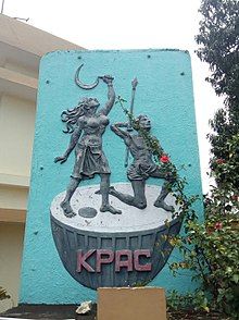
KPAC drama troupe
[edit]Kerala People's Arts Club (KPAC) is a theatrical movement in Kayamkulam, Kerala. It was formed in the 1950s by a group of individuals that had close ties with the leftist parties of Kerala.

In 1951 KPAC staged its first drama, Ente Makananu Sari (transl. "My Son is Right"), whose songs were written by Punaloor Balan. Its second drama Ningalenne Communistakki (transl. "You Made Me a Communist") was first performed in 1952. The success of Ningalenne Communistakki brought KPAC to the forefront of a powerful people's theatre movement in Kerala.[13]
KPAC played a significant role in popularising the Communist Party in Kerala through its dramas, road shows and kathaprasangams (story telling).[14]
Power plant
[edit]The Rajiv Gandhi Combined Cycle Power Plant is a combined cycle power plant located in Cheppad, Haripad, Alappuzha district, Kerala.
Notable people
[edit]- Thopil Bhasi – Malayalam playwright, screenwriter, and film director
- K. M. Cherian – heart surgeon; founder of Frontier Lifeline Hospital and the Dr. K M Cherian Heart Foundation
- Kambisseri Karunakaran – journalist, politician, actor, satirist and rationalist
- P. Kesavadev – novelist, writer, and social reformer
- Kayamkulam Kochunni – highwayman based in Kayamkulam, active in Central Travancore in the early 19th century
- K. P. A. C. Lalitha – National Award-winning Indian film and stage actress
- S. Guptan Nair – Malayalam writer, critic, scholar and educationist
- K. Shankar Pillai – cartoonist, founder of Shankar's Weekly
- Thachadi Prabhakaran – former Minister of Kerala
- Kayamkulam Philipose Ramban – Christian priest
- T. P. Sreenivasan - diplomat; former High Commissioner to Fiji and Kenya and Ambassador to Austria
See also
[edit]- Pathiyoor
- Kattanam
- Charummood
- Mavelikkara
- Adoor
- Pandalam
- Chengannur
- Mannar
- Vallikunnam
- Alappuzha Lok Sabha constituency
- Oachira
- Padanilam
- Chettikulangara
- Puthuppally
References
[edit]- ^ https://lsgkerala.gov.in/system/files/2017-10/localbodies.pdf [bare URL PDF]
- ^ "Kerala (India): Districts, Cities and Towns - Population Statistics, Charts and Map".
- ^ https://lsgkerala.gov.in/system/files/2017-10/localbodies.pdf [bare URL PDF]
- ^ Lonely Planet Things to do in Southern Kerala by Lonely Planet travellers.
- ^ Department of Archeology WebsiteArchived 2011-01-22 at the Wayback Machine.
- ^ First Kayamkulam boat race.
- ^ Kerala boat races Archived 28 June 2012 at the Wayback Machine.
- ^ "Census of India 2001: Data from the 2001 Census, including cities, villages and towns (Provisional)". Census Commission of India. Archived from the original on 16 June 2004. Retrieved 1 November 2008.
- ^ Census India 2001.
- ^ Census India 2011.
- ^ "Assembly Constituencies - Corresponding Districts and Parliamentary Constituencies" (PDF). Kerala. Election Commission of India. Archived from the original (PDF) on 4 March 2009. Retrieved 20 October 2008.
- ^ "ICAR-Central Plantation Crops Research Institute".
- ^ "Frontline article". Archived from the original on 30 December 2001. Retrieved 2 October 2016.
- ^ "First Ministry of Kerala Government". Archived from the original on 2 October 2008. Retrieved 2 October 2016.


