Rüdersdorf
Rüdersdorf | |
|---|---|
 Open-air museum in Rüdersdorf | |
Location of Rüdersdorf within Märkisch-Oderland district  | |
| Coordinates: 52°28′18″N 13°47′04″E / 52.47167°N 13.78444°E | |
| Country | Germany |
| State | Brandenburg |
| District | Märkisch-Oderland |
| Subdivisions | 4 Ortsteile |
| Government | |
| • Mayor (2019–27) | Sabine Löser[1] |
| Area | |
• Total | 70.11 km2 (27.07 sq mi) |
| Elevation | 62 m (203 ft) |
| Population (2022-12-31)[2] | |
• Total | 16,014 |
| • Density | 230/km2 (590/sq mi) |
| Time zone | UTC+01:00 (CET) |
| • Summer (DST) | UTC+02:00 (CEST) |
| Postal codes | 15562 |
| Dialling codes | 033638 |
| Vehicle registration | MOL |
| Website | www.ruedersdorf.de |
Rüdersdorf is a municipality in the district Märkisch-Oderland, in Brandenburg, Germany, near Berlin.
It is served by the Schöneiche bei Berlin tramway which runs from Rüdersdorf through Schöneiche to Berlin-Friedrichshagen station on the Berlin S-Bahn network. Bundesautobahn 10 passes through the town.
Overview
[edit]The municipality is situated 26 km (16 mi) east of Berlin centre and includes the three districts Hennickendorf, Herzfelde and Lichtenow. Rüdersdorf is noted for its open-cast limestone mine. Today, some parts of the mine are used as a museum Museumspark Rüdersdorf. Notable buildings in Berlin such as the Brandenburg Gate and the Olympiastadium were built with limestone from Rüdersdorf.
Demography
[edit]-
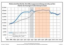
Development of Population since 1875 within the Current Boundaries (Blue Line: Population; Dotted Line: Comparison to Population Development of Brandenburg state; Grey Background: Time of Nazi rule; Red Background: Time of Communist rule)
-
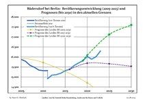
Recent Population Development and Projections (Population Development before Census 2011 (blue line); Recent Population Development according to the Census in Germany in 2011 (blue bordered line); Official projections for 2005-2030 (yellow line); for 2017-2030 (scarlet line); for 2020-2030 (green line)
|
|
|
Coat of arms
[edit]
The coat of arms of Gemeinde Rüdersdorf bei Berlin shows a rooted green lime tree with two red shields on its side. The shield towards the left of the trunk shows the silver hammer and pick as a symbol for the limestone quarrying: An industry which has shaped this municipality and is still present to this day. On the right side of the trunk, the shield symbolizes a silver turnip which represents the local agriculture. Both industries have been implanted back in the 13th century by the monks of the Zinna Abbey.[4]
Notable people
[edit]- Johanna Elberskirchen (1864–1943), activist
- Andreas Thom (born 1965), footballer
- Karla Woisnitza (born 1952), artist
- Giacomo Meyerbeer (1791–1864), opera composer
Partnerships with other communes
[edit]- Hemmoor in Lower Saxony, since 1991
- Pierrefitte-sur-Seine in France, since 1966
- Lomma Municipality in Sweden, since 2007
- Popielów in Poland, since 1997
References
[edit]- ^ Landkreis Märkisch-Oderland Wahl der Bürgermeisterin / des Bürgermeisters, accessed 1 July 2021.
- ^ "Bevölkerungsentwicklung und Bevölkerungsstandim Land Brandenburg Dezember 2022" (PDF). Amt für Statistik Berlin-Brandenburg (in German). June 2023.
- ^ Detailed data sources are to be found in the Wikimedia Commons.Population Projection Brandenburg at Wikimedia Commons
- ^ "Rüdersdorf bei Berlin - Unsere Gemeinde". www.ruedersdorf.de. Retrieved 2017-08-10.
External links
[edit]![]() Media related to Rüdersdorf at Wikimedia Commons
Media related to Rüdersdorf at Wikimedia Commons


