Jezero, Bosnia and Herzegovina
This article needs additional citations for verification. (February 2021) |
Jezero
Језеро | |
|---|---|
Village and municipality | |
 | |
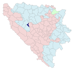
 Location of Jezero within Bosnia and Herzegovina | |
 | |
| Coordinates: 44°21′0″N 17°10′5″E / 44.35000°N 17.16806°E | |
| Country | |
| Entity | |
| Geographical region | Bosanska Krajina |
| Government | |
| • Municipal mayor | Snežana Ružičić (SNSD) |
| Area | |
• Total | 55.6 km2 (21.5 sq mi) |
| Population (2013) | |
• Total | 1,144 |
| • Density | 21/km2 (53/sq mi) |
| Time zone | UTC+1 (CET) |
| • Summer (DST) | UTC+2 (CEST) |
| Area code | 387 (50) |
| Website | www |
Jezero (Serbian Cyrillic: Језеро, lit. "Lake") is a village and a municipality in Republika Srpska, Bosnia and Herzegovina. As of 2013, it has a population of 1,144 inhabitants, while the village of Jezero has a population of 581 inhabitants.[1] A small part of the village in Jajce municipality has a population of 6.[2]
Etymology
[edit]The village name Jezero derives from the word jezero which in most Slavic languages (Bulgarian, Macedonian: езеро, Serbian: jезеро/jezero, Bosnian, Croatian, Czech, Slovene: jezero) and its closest written variations (Polish: jezioro, Lower Sorbian: jezer, Slovak: jazero, Russian and Ukrainian: озеро), as well as in Baltic languages (Lithuanian: ežeras, Latvian: ezers) means "lake".[3]
Geography
[edit]Physical geography
[edit]The Jezero municipality consists of hills, mountains and basins. The altitude is between 432 and 1267 meters, the highest mountains in the municipality are Gorica and Sinjakovo. The rivers that flow through the Jezero municipality are Pliva and Jošavka as well as their tributaries. Jezero is situated on location where the Pliva river enters Veliko Plivsko Lake.
Political geography
[edit]The Jezero municipality is located in the northeastern part of Republika Srpska. It borders the municipalities of Mrkonjić Grad, Jajce and Šipovo. The Jezero municipality is one of the smaller municipalities of Republika Srpska, with an area of 55,6 km2 and makes up 0,23% of the total territory of the Republic of Srpska.
Climate
[edit]The area of the Jezero municipality belongs to the zone of temperate continental climate with the average annual temperature of is 10.5 °C. The average annual rainfall is about 981 mm, and is evenly distributed throughout the year.
History
[edit]Ancient times
[edit]Jezero has had a long history. It is supposed that there had been a settlement at that area even in the Illyrian period and, according to traditional stories, as the Illyrian queen Teuta had ordered, the channel was dug so that the Illyrian fortress was established on the river island where the large part of settlement is still located. Roads passed through Jezero in Roman period and in the Middle Ages. The fortress on the river island was conquered by the Ottoman military during their conquest of Bosnia in 1463.
Formation of Jezero municipality
[edit]Before the war, the municipality of Jezero was a local community and belonged to the municipality of Jajce. After the signing of the Dayton Agreement (The General Framework Agreement for Peace in Bosnia and Herzegovina), inter-entity boundary line separated Jezero from Jajce. Thus the municipality of Jezero was established by the decision of the National Assembly of Republika Srpska in June 1996.
Demographics
[edit]Population
[edit]| Population of settlements – Jezero municipality | ||||||||
|---|---|---|---|---|---|---|---|---|
| Settlement | 1948. | 1953. | 1961. | 1971. | 1981. | 1991. | 2013. | |
| Total | 2,604 | 3,323 | 1,949 | 1,144 | ||||
| 1 | Borci | 227 | ||||||
| 2 | Čerkazovići | 220 | ||||||
| 3 | Drenov Do | 145 | ||||||
| 4 | Đumezlije | 92 | ||||||
| 5 | Jezero | 655 | 595 | 728 | 834 | 702 | ||
| 6 | Kovačevac | 131 | ||||||
| 7 | Ljolići | 205 | ||||||
| 8 | Perućica | 95 | ||||||
Ethnic composition
[edit]| Ethnic composition – Jezero | |||||||
|---|---|---|---|---|---|---|---|
| 2013. | 1991. | 1981. | 1971. | ||||
| Total | 702 (100,0%) | 834 (100,0%) | 728 (100,0%) | 595 (100,0%) | |||
| Bosniaks | 477 (57,19%) | 409 (56,18%) | 435 (73,11%) | ||||
| Serbs | 282 (33,81%) | 245 (33,65%) | 131 (22,02%) | ||||
| Yugoslavs | 34 (4,077%) | 46 (6,319%) | 6 (1,008%) | ||||
| Croats | 33 (3,957%) | 13 (1,786%) | 19 (3,193%) | ||||
| Others | 8 (0,959%) | 9 (1,236%) | 4 (0,672%) | ||||
| Albanians | 6 (0,824%) | ||||||
| Ethnic composition – Jezero municipality | ||||||||||
|---|---|---|---|---|---|---|---|---|---|---|
| 2013. | 1991. | 1981. | 1971. | |||||||
| Total | 1,144 (100,0%) | 834 (100,0%) | 728 (100,0%) | 595 (100,0%) | ||||||
| Bosniaks | 287 (25,087%) | 477 (57,19%) | 409 (56,18%) | 435 (73,10%) | ||||||
| Serbs | 841 (73,51%) | 282 (33,81%) | 245 (33,65%) | 131 (22,01%) | ||||||
| Croats | 11 (0,962%) | 33 (3,95%) | 13 (1,78%) | 19 (3,19%) | ||||||
| Yugoslavs | 34 (4,07%) | 46 (6,31%) | 6 (1,00%) | |||||||
| Others | 5 (0,437%) | 8 (0,95%) | 15 (2,06%) | 4 (0,67%) | ||||||
Tourism
[edit]The municipality of Jezero has significant water potential (rivers Pliva, Jošavka and rivers of Perućica, lake Đol in Ljoljići). Those potentials can be used for the development of tourism and hydro potential, ecology and protection of healthy environment.
The municipality Jezero is located on the river Pliva, halfway between Jajce and Šipovo at an altitude of 430 m. What is specific for Jezero is that it is located exactly on the confluence of the river Pliva with Great Pliva Lake, surrounded with beautiful mountain range. Except Pliva Lake, there are two more lakes nearby, those are Veliki Đol (Great Đol) and Mali Đol (Small Đol), places remarkably famous among the fishermen. Besides, Jezero has excellent conditions for paragliding, mountaineering and mountain-biking.
-
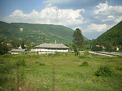
Former railway station
-
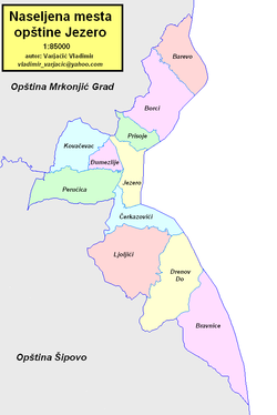
Jezero Municipality area
-
Temple of Holy Martyr Prince Lazar in Jezero
Jezero on Mars
[edit]In 2007, following the discovery of an ancient crater-lake on planet Mars, the feature was named Jezero Crater, after this village in Bosnia and Herzegovina,[4][5] which is one of the country's several eponymous towns and villages.[6]
In November 2018, it was announced that Jezero Crater had been chosen as the landing site for the planned Mars 2020 rover mission.[7][8][9]
Sister relationships
[edit]- Susami, Japan
References
[edit]- ^ "B&H 2013 census - Jezero Municipality". Retrieved 31 August 2020.
- ^ "Naseljena Mjesta 1991/2013" (in Bosnian). Statistical Office of Bosnia and Herzegovina. Retrieved 14 November 2021.
- ^ Трубачёв, Олег Николаевич, ed. (1979). Этимологический словарь славянских языков [Etymological dictionary of Slavic languages] (in Russian). Vol. Вып. 6 (*e — *golva). М.: Наука. pp. 33–34.
- ^ Lakdawlla, Emily (20 November 2018). "We're going to Jezero!". Planetary Society. Retrieved 9 December 2018.
- ^ "Pro-ruski savez na (ne)djelu: Dodik i Čović odbili doći na proslavu Dana nezavisnosti SAD-a" [4th July celebration at USA Embassy in Sarajevo]. slobodna-bosna.ba (in Bosnian). 3 July 2019. Retrieved 3 July 2019.
- ^ "Planetary names: Crater, craters: Jezero on Mars". planetarynames.wr.usgs.gov. Retrieved 14 December 2018.
- ^ Chang, Kenneth (19 November 2018). "NASA Mars 2020 rover gets a landing site: A crater that contained a lake – The rover will search the Jezero Crater and delta for the chemical building blocks of life and other signs of past microbes". The New York Times. Retrieved 21 November 2018.
- ^ Wall, Mike (19 November 2018). "Jezero Crater or bust! NASA picks landing site for Mars 2020 rover". Space.com. Retrieved 20 November 2018.
- ^ Mandelbaum, Ryan F. "NASA's Mars 2020 rover will land in Jezero Crater". Gizmodo. Retrieved 19 November 2018.
- ^ "PIA19303: A possible landing site for the 2020 mission: Jezero Crater" (Press release). NASA. 4 March 2015. Retrieved 7 March 2015.
- ^ Goudge, Timothy A.; Mustard, John F.; Head, James W.; Fassett, Caleb I.; Wiseman, Sandra M. (6 March 2015). "Assessing the mineralogy of the watershed and fan deposits of the Jezero Crater paleolake system, Mars". Journal of Geophysical Research. 120 (4): 775. Bibcode:2015JGRE..120..775G. doi:10.1002/2014JE004782.
- ^ Wray, James (6 June 2008). "Channel into Jezero Crater delta". Lunar and Planetary Laboratory (University of Arizona, Tucson) (Press release). NASA. Retrieved 6 March 2015.
- ^ RBurnham (19 November 2018). "Overflowing crater lakes carved Mars canyon". Red Planet Report. Retrieved 20 November 2018.
- ^ "Overflowing crater lakes carved canyons across Mars" (Press release). University of Texas at Austin. 19 November 2018. Retrieved 20 November 2018.


