Hồng Lĩnh
Appearance
(Redirected from Hồng Lĩnh District)
You can help expand this article with text translated from the corresponding article in Vietnamese. (March 2009) Click [show] for important translation instructions.
|
Hồng Lĩnh | |
|---|---|
| Hồng Lĩnh Town Thị xã Hồng Lĩnh | |
 | |
| Nickname: Blue River lighted-up Pink Mountain (Sông Lam rọi Núi Hồng) | |
 Interactive map outlining Hồng Lĩnh | |
| Country | |
| Region | North Central Coastal |
| Province | Hà Tĩnh Province |
| Established | 2 March 1992 |
| Capital | Hồng Lĩnh |
| Area | |
• Total | 22.6 sq mi (58.5 km2) |
| Population (2009) | |
• Total | 40,805 |
| • Density | 1,807/sq mi (697.5/km2) |
| Time zone | UTC+7 (Indochina Time) |
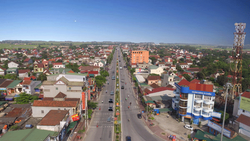
Hồng Lĩnh is a town in Hà Tĩnh Province in the North Central Coast region of Vietnam. It is near the Lam river and the 99 peaks of the Hồng Lĩnh mountains. As of 2003 the city had a population of 35,102.[1] The district covers an area of 58 km². The district capital lies at Hồng Lĩnh.[1] Hồng Lĩnh town was scheduled for urban water supply in 2002[2] and given priority status for investment in 2005.[3] In business directories the town is listed as "Hồng Lĩnh Town."[4] The town is on the A1 Highway and subject to flooding.[5]
References
[edit]- ^ a b "Districts of Vietnam". Statoids. Retrieved March 20, 2009.
- ^ Tổng quan quy hoạch phát triển kinh tế-xã hội Việt Nam - Volume 2 - Page 745 Hoàng Kim Trần, Hội khoa học kinh tế Việt Nam. Trung tâm thông tin và tư vấn phát triển - 2002 "To the urban area completing the works of water supply and drainage in Ha Tinh town, Hong Linh town and other district's towns to make safe water available to every urban households."
- ^ Dao Nguyen Cat Vietnam, opportunities for investors 2005- Page 171 "The province gives priority to building hotels, supermarkets, parks, and entertainment centres, etc., in convenient locations for transport, electricity, water, and telecommunications, such as in Ha Tinh town, Hong Linh town, Thien Cam, ..."
- ^ Vietnam Business Directory CONSTRUCTION CO.NO.2. Contact Name: Address: 99 Highway 8A, Nam Hồng Ward, Hồng Lĩnh Town
- ^ Vietbao 24 Feb 2008 "Heavy rains continuously for two days gave rise to localized flooding in the town of Hong Linh (Ha Tinh), flooding houses, traffic on highway 1A."

