Guamo Embarcadero
Appearance
Guamo Embarcadero
Guamo | |
|---|---|
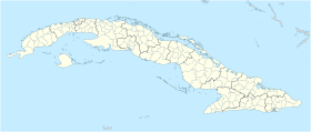
Location of Guamo Embarcadero in Cuba | |
| Coordinates: 20°36′59″N 76°57′32″W / 20.61639°N 76.95889°W | |
| Country | |
| Province | Granma |
| Municipality | Río Cauto |
| Area | |
• Total | 0.8292 km2 (0.3202 sq mi) |
| Elevation | 10 m (30 ft) |
| Population (2012)[1] | |
• Total | 3,840 |
| • Density | 4,631/km2 (11,990/sq mi) |
| Time zone | UTC-5 (EST) |
Guamo Embarcadero, simply known as Guamo, is a Cuban village and consejo popular ("people's council", i.e. hamlet) of the municipality of Río Cauto, in Granma Province of Cuba. It is located 45 kilometres (28 mi) northwest of Bayamo, the provincial capital.[2]
History
[edit]The rural village of Guamo, situated on Cuba's longest river, the Cauto River, was originally part of the township or municipal district of Bayamo in the province of Oriente in Cuba.[3]
Following the 1976 Cuban constitutional referendum, Guamo Embarcadero became part of the Río Cauto municipality in Granma Province.[citation needed]
Demographics
[edit]In 2012, the settlement of Guamo Embarcadero had a population of 3,840.[1]
See also
[edit]References
[edit]- ^ a b "Cuba: Administrative Division (Provinces and Municipalities) - Population Statistics, Charts and Map". www.citypopulation.de. Retrieved 2024-08-25.
- ^ Publications. (1909). United States: (n.p.).
- ^ Census of Cuba ...: Bulletin. (1900). United States: U.S. Government Printing Office.

