Gielniów
Gielniów | |
|---|---|
Town | |
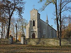
 Ladislaus of Gielniów church | |
| Coordinates: 51°23′N 20°29′E / 51.383°N 20.483°E | |
| Country | |
| Voivodeship | Masovian |
| County | Przysucha |
| Gmina | Gielniów |
| Elevation | 209 m (686 ft) |
| Population | |
• Total | 1,100 |
| Time zone | UTC+1 (CET) |
| • Summer (DST) | UTC+2 (CEST) |
| Vehicle registration | WPY |
Gielniów [ˈɡʲɛlɲuf] is a town in Przysucha County, Masovian Voivodeship, in east-central Poland. It is the seat of the gmina (administrative district) called Gmina Gielniów.[1] It lies northern part of historic Lesser Poland, approximately 10 kilometres (6 mi) west of Przysucha and 100 km (62 mi) south of Warsaw.
History
[edit]Gielniów used to be a town from 1455 until either 1869 or 1870. It received Magdeburg rights due to efforts of a local nobleman Tomasz Mszczuj of Brzezinki. Until the Partitions of Poland, Gielniów belonged to Sandomierz Voivodeship in the Lesser Poland Province, but it remained a very small town, whose population was app. 100 (as for the mid-17th century). In 1815-1915, Gielniów was part of Russian-controlled Congress Poland, losing its town charter after the failed January Uprising. In the mid-19th century, its population was app. 500, and after losing the charter, Gielniów declined.
References
[edit]External links
[edit]- Jewish Community in Gielniów on Virtual Shtetl
- Gielniów, Poland at JewishGen


