Gaiemmae Station
Appearance
(Redirected from Gaienmae Station)
This article needs additional citations for verification. (May 2022) |
G03 Gaiemmae Station 外苑前駅 | |||||||||||
|---|---|---|---|---|---|---|---|---|---|---|---|
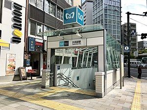
 Exit3 in October 2018 | |||||||||||
| General information | |||||||||||
| Location | 2-7-16 Kita-Aoyama, Minato, Tokyo Japan | ||||||||||
| Operated by | |||||||||||
| Line(s) | G Ginza Line | ||||||||||
| Platforms | 2 side platforms | ||||||||||
| Tracks | 2 | ||||||||||
| Construction | |||||||||||
| Structure type | Underground | ||||||||||
| Other information | |||||||||||
| Station code | G-03 | ||||||||||
| Website | www | ||||||||||
| History | |||||||||||
| Opened | 18 November 1938 | ||||||||||
| Previous names | Aoyama-yonchōme (until 1939) | ||||||||||
| Passengers | |||||||||||
| FY2016 | 78,309 daily[1] | ||||||||||
| Services | |||||||||||
| |||||||||||
| |||||||||||
Gaiemmae Station (外苑前駅, Gaienmae-eki) is a subway station on the Tokyo Metro Ginza Line in Minato, Tokyo, Japan, operated by the Tokyo subway operator Tokyo Metro.
Station layout
[edit]The station has two side platforms serving two tracks.
Platforms
[edit]| 1 | G Ginza Line | for Shibuya |
| 2 | G Ginza Line | for Akasaka-mitsuke, Ginza, Ueno, and Asakusa |
-
Concourse
-
Platforms
History
[edit]The station opened as Aoyama-yonchōme Station on November 18, 1938, and was renamed Gaiemmae in 1939.
The station facilities were inherited by Tokyo Metro after the privatization of the Teito Rapid Transit Authority (TRTA) in 2004.[2]
Surrounding area
[edit]- Watari Museum of Contemporary Art
- Itochu
- Avex
- Oracle Corporation Japan
- Aoyama Cemetery
- Meiji Shrine Outer Gardens (明治神宮外苑 (Meiji Jingu Gaien))
- Meiji Jingu Stadium (baseball stadium)
- Chichibunomiya Rugby Stadium
- National Olympic Stadium
References
[edit]- ^ "Gaiemmae Station information". Japan: Tokyo Metro Co., Ltd. Retrieved 3 January 2018.
- ^ "「営団地下鉄」から「東京メトロ」へ" [From "Teito Rapid Transit Authority" to "Tokyo Metro"]. Tokyo Metro Online. 2006-07-08. Archived from the original on 16 May 2012. Retrieved 29 May 2022.
External links
[edit]Wikimedia Commons has media related to Gaiemmae Station.
- Official website (in Japanese)


