Metropolitan France

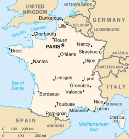
Metropolitan France (French: France métropolitaine or la Métropole), also known as European France,[1][a] is the area of France which is geographically in Europe. This collective name for the European regions of France is used in everyday life in France but has no administrative meaning, with the exception of only Metropolitan France being part of the Schengen Area.[2] Indeed, the overseas regions have exactly the same administrative status as the metropolitan regions. Metropolitan France comprises mainland France and Corsica, as well as nearby French islands in the Atlantic Ocean, the English Channel (French: la Manche), and the Mediterranean Sea. Its borders have undergone significant changes over the centuries, particularly in the east, but have remained unaltered since 1947.
In contrast, overseas France (France d'outre-mer) is the collective name for all the French departments and territories outside Europe. Metropolitan and overseas France together form the French Republic. Metropolitan France accounts for 82.0% of the land territory, 3.3% of the exclusive economic zone (EEZ), and 95.9% of the population of the French Republic. Some small parts of France (e.g. Cerdanya) are a part of the Iberian Peninsula.
In overseas France, a person from metropolitan France is often called a métro, short for métropolitain.
Etymology
[edit]The term "metropolitan France" dates from the country's colonial period (from the 16th to the 20th centuries), when France was referred to as la Métropole (literally "the Metropolis"), as distinguished from its colonies and protectorates, known as les colonies or l'Empire. Similar terms existed to describe other European colonial powers (e.g. "metropolitan Britain", "España metropolitana"). This application of the words "metropolis" and "metropolitan" came from Ancient Greek "metropolis" (from μήτηρ mētēr "mother" and πόλις pólis "city, town"), which was the name for a city-state that created colonies across the Mediterranean (e.g. Marseille was a colony of the city-state of Phocaea; therefore Phocaea was the "metropolis" of Marseille). By extension "metropolis" and "metropolitan" came to mean "motherland", a nation or country as opposed to its colonies overseas.

Today, some people[who?] in Overseas France object to the use of the term la France métropolitaine due to its colonial history. They prefer to call it "the European territory of France" (le territoire européen de la France), as the Treaties of the European Union do.[citation needed] Likewise, they oppose treating overseas France and metropolitan France as separate entities. For example, INSEE used to calculate its statistics (demography, economy, etc.) for metropolitan France only, and to analyze separate statistics for the overseas departments and territories. People in the overseas departments have opposed this separate treatment, arguing that the then four overseas departments were fully part of France.[citation needed]
As a result, since the end of the 1990s INSEE has included the four overseas departments in its figures for France (such as total population or GDP). The fifth overseas department, Mayotte, has been included in the figures for France since the mid-2010s too. INSEE refers to metropolitan France and the five overseas departments as la France entière ("the whole of France"). "The whole of France" includes the five overseas departments, but does not include the other overseas collectivities and territories that have more autonomy than the departments. Other branches of the French administration may have different definitions of what la France entière is. For example, in contrast to INSEE, when the Ministry of the Interior releases election results, they use the term la France entière to refer to the entire French Republic, including all of overseas France, and not just the five overseas departments.
Since INSEE now calculates statistics for la France entière, this practice has spread to international institutions. For instance, the French GDP published by the World Bank includes metropolitan France and the five overseas departments. The World Bank refers to this total as "France"; it does not use the phrase "the whole of France", as INSEE does.
Statistics
[edit]Metropolitan France covers a land area of 543,940 km2 (210,020 sq mi),[b] while overseas France covers a land area of 119,396 km2 (46,099 sq mi),[3] for a total of 663,336 km2 (256,115 sq mi) in the French Republic (excluding Adélie Land in Antarctica where sovereignty is suspended since the signing of the Antarctic Treaty in 1959). Thus, metropolitan France accounts for 82.0% of the French Republic's land territory.
At sea, the exclusive economic zone (EEZ) of metropolitan France covers 333,691 km2 (128,839 sq mi), while the EEZ of Overseas France covers 9,825,538 km2 (3,793,661 sq mi), for a total of 10,159,229 km2 (3,922,500 sq mi) in the French Republic (excluding Adélie Land).[4] Thus, metropolitan France accounts for 3.3% of the French Republic's EEZ.
According to INSEE, 66,143,000 people lived in metropolitan France as of January 2024, while 2,220,000 lived in the French Overseas Department (DOM) and another 600,000 in the Overseas Collectivities (TOM), for a total of 2,820,000 inhabitants in Oversea France. The total population of all French controlled land is 68,963,000 people. But the Overseas Collectivities are not included in the INSEE statistics.[5] Thus, metropolitan France accounts for 95.9% of the French Republic's population.
In the second round of the 2017 French presidential election, 35,467,327 French people cast a ballot (meaning a turnout of 74.56%). 33,883,463 of these (95.53% of the total voters) cast their ballots in metropolitan France (turnout: 76.26%), 1,003,910 (2.83% of the total voters) cast their ballots in overseas France (turnout: 53.59%), and 579,954 (1.64% of the total voters) cast their ballots in foreign countries (French people living abroad; turnout: 45.84%).[6]
The French National Assembly is made up of 577 deputies, 539 of whom (93.4% of the total) are elected in metropolitan France, 27 (4.7% of the total) in overseas France, and 11 (1.9% of the total) by French citizens living in foreign countries.
Hexagon
[edit]
Legislators in 2023 voted to use the name l'Hexagone ("the Hexagon") to refer to what had previously been known as metropolitan France in an effort to move away from colonial language.[7] The image of France as a hexagon first appeared in French geography texts of the 1850s.[8]
Mainland or Continental France (French: la France continentale), or just "the mainland" (French: le continent), does not include the French islands in the Atlantic Ocean, English Channel, or Mediterranean Sea, the largest of which is Corsica. In Corsica, people from mainland France are referred to as les continentaux.
See also
[edit]Notes
[edit]- ^ Without Corsica, metropolitan France is also known as l'Hexagone ("the Hexagon").
- ^ French Land Register data, which exclude lakes, ponds and glaciers larger than 1 km2 (0.39 sq mi) as well as the estuaries of rivers. French National Geographic Institute data, which includes bodies of water, gives a value of 551,695 km2 (213,011 sq mi) for the land area of metropolitan France.
References
[edit]- ^ (French: Territoire européen de la France) "Ministère des Affaires Étrangères- Les étrangers titulaires d'un passeport ordinaire dispensés de l'obligation de visa - 1. Le territoire européen de la France" (in French). Archived from the original on 2017-02-25. Retrieved 2018-05-15.
- ^ https://france-visas.gouv.fr/en/france-in-the-schengen-area [bare URL]
- ^ Land area of the four old overseas departments ([1]), Mayotte, the overseas collectivities, and New Caledonia (page 21), the French Southern and Antarctic Lands and the Scattered Islands ([2] Archived 2018-06-19 at the Wayback Machine), and Clipperton ([3]).
- ^ "Sea Around Us – Fisheries, Ecosystems and Biodiversity". Retrieved 2018-06-20.
- ^ Population of Metropolitan France: [4]. The population of all five overseas departments totaled 2,172,000 [5] in January 2024. The population of the overseas collectivities amounted to 613,000 inhabitants (Saint-Pierre and Miquelon [6], Saint-Barthélemy [7], Saint-Martin [8], French Polynesia [9], Wallis et Futuna [10], New Caledonia [11]). The total population of the overseas departments and territories of France is estimated at 2,785,000.
- ^ "Résultats de l'élection présidentielle 2017". Minister of the Interior (in French). Government of France. Retrieved 2018-06-20.
- ^ Postollec, Julie (2023-05-24). "L'Assemblée nationale abandonne le terme 'métropole', jugé colonial, dans un texte de loi". La premiere: France TV (in French).
- ^ Peter Sahlins, "Natural Frontiers Revisited: France's Boundaries since the Seventeenth Century", The American Historical Review, Vol. 95, No. 5 (Dec., 1990), p. 1451
