Jump to content

File:Yukon Delta.jpg

This is a file from the Wikimedia Commons
From Wikipedia, the free encyclopedia

Original file (17,631 × 17,053 pixels, file size: 136.36 MB, MIME type: image/jpeg)

Summary

Warning The original file is very high-resolution. It might not load properly or could cause your browser to freeze when opened at full size. Open in ZoomViewer
Description
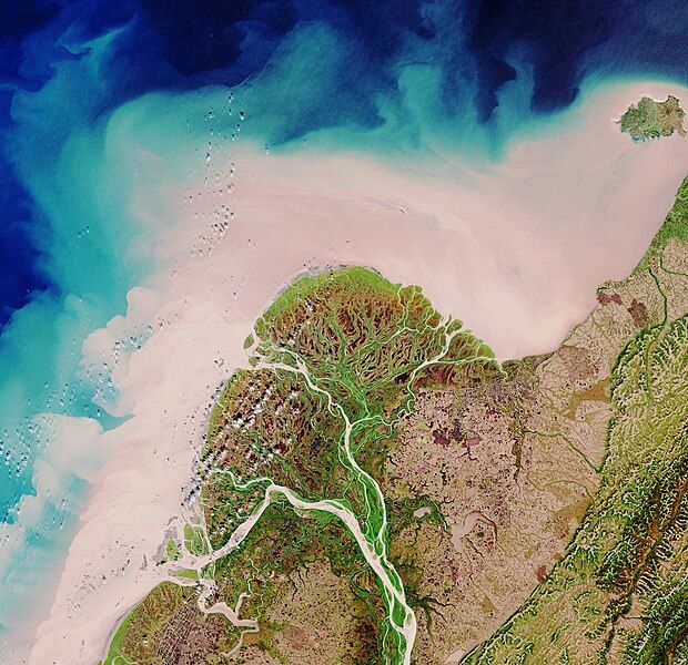
English: The Copernicus Sentinel-2 mission takes us over part of the Yukon Delta in the US state of Alaska.

The Yukon River rises in British Columbia in Canada and flows through Yukon Territory before entering Alaska and finally draining into the Bering Sea. This image, recorded on 29 August 2017, shows how the river branches off into numerous channels that meander through the low-lying terrain on their way to the sea. The sandy colour of these channels and of the coastal water illustrates how much sediment the river carries to the sea at this time of year.

It is estimated that 95% of all sediment transported during an average year occurs between May and September. During the other seven months, concentrations of sediment and other water-quality constituents are low. However, scientists also believe that sediment flow has increased over the last few decades because permafrost is thawing in the Yukon River Basin and ice breakup occurs earlier in the year owing to warmer air temperatures. This is important because elevated concentrations can adversely affect aquatic life by obstructing fish gills, covering fish spawning sites, and altering habitat of bottom-dwelling organisms. Metals and organic contaminants also tend to absorb onto fine-grained sediment.

The Copernicus Sentinel-2 satellites each carry a high-resolution camera that images Earth’s surface in 13 spectral bands. While the mission is mostly used to track changes in the way land is being used and to monitor the health of our vegetation, it also provides information on the condition of coastal waters.

This image is featured on theEarth from Space video programme.
Date
Source http://www.esa.int/spaceinimages/Images/2018/01/Yukon_Delta
Author European Space Agency
Permission
(Reusing this file)
contains modified Copernicus Sentinel data (2017), processed by ESA,CC BY-SA 3.0 IGO
Other versions
Title
InfoField
Yukon Delta
System
InfoField
Copernicus
Set
InfoField
Earth observation image of the week
Location
InfoField
USA
Mission
InfoField
Sentinel-2
Activity
InfoField
Observing the Earth

Assessment

Featured picture

Wikimedia CommonsWikipedia

This is a featured picture on Wikimedia Commons (Featured pictures) and is considered one of the finest images. See its nomination here.

 This is a featured picture on the English language Wikipedia (Featured pictures) and is considered one of the finest images. See its nomination here.

If you have an image of similar quality that can be published under a suitable copyright license, be sure to upload it, tag it, and nominate it.

Licensing

w:en:Creative Commons
attribution share alike
This file is licensed under the Creative Commons Attribution-ShareAlike 3.0 IGO license.
You are free:
  • to share – to copy, distribute and transmit the work
  • to remix – to adapt the work
Under the following conditions:
  • attribution – You must give appropriate credit, provide a link to the license, and indicate if changes were made. You may do so in any reasonable manner, but not in any way that suggests the licensor endorses you or your use.
  • share alike – If you remix, transform, or build upon the material, you must distribute your contributions under the same or compatible license as the original.
© This image contains data from a satellite in the Copernicus Programme, such as Sentinel-1, Sentinel-2 or Sentinel-3. Attribution is required when using this image.
Attribution: Contains modified Copernicus Sentinel data {{{year}}}

The use of Copernicus Sentinel Data is regulated under EU law (Commission Delegated Regulation (EU) No 1159/2013 and Regulation (EU) No 377/2014). Relevant excerpts:


Financial conditions

Free access shall be given to GMES dedicated data [...] made available through GMES dissemination platforms [...].

Conditions regarding use

Access to GMES dedicated data [...] shall be given for the purpose of the following use in so far as it is lawful:

  1. reproduction;
  2. distribution;
  3. communication to the public;
  4. adaptation, modification and combination with other data and information;
  5. any combination of points (a) to (d).

GMES dedicated data [...] may be used worldwide without limitations in time.

Conditions regarding information to be given by users
  1. When distributing or communicating GMES dedicated data [...] to the public, users shall inform the public of the source of that data and information.
  2. Users shall make sure not to convey the impression to the public that the user’s activities are officially endorsed by the Union.
  3. Where that data or information has been adapted or modified, the user shall clearly state this.
Absence of warranty

GMES dedicated data and GMES service information are provided to users without any express or implied warranty, including as regards quality and suitability for any purpose.

Annotations
InfoField
This image is annotated: View the annotations at Commons

Captions

Add a one-line explanation of what this file represents

Items portrayed in this file

depicts

26 January 2018

image/jpeg

File history

Click on a date/time to view the file as it appeared at that time.

Date/TimeThumbnailDimensionsUserComment
current05:43, 8 February 2021Thumbnail for version as of 05:43, 8 February 202117,631 × 17,053 (136.36 MB)StellarHaloUploaded a work by European Space Agency from http://www.esa.int/spaceinimages/Images/2018/01/Yukon_Delta with UploadWizard

Global file usage