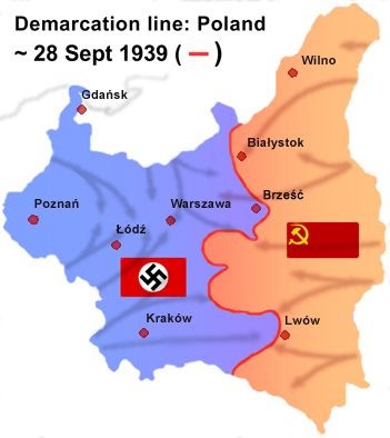
File:Wrzesien2.jpg
Appearance
Wrzesien2.jpg (351 × 394 pixels, file size: 74 KB, MIME type: image/jpeg)
File history
Click on a date/time to view the file as it appeared at that time.
| Date/Time | Thumbnail | Dimensions | User | Comment | |
|---|---|---|---|---|---|
| current | 05:39, 7 February 2016 |  | 351 × 394 (74 KB) | Poeticbent | added directions of the 1939 attack |
| 18:06, 6 April 2015 |  | 351 × 394 (67 KB) | Poeticbent | added Brześć (significant) | |
| 16:44, 25 July 2011 |  | 351 × 394 (25 KB) | Lonio17 | city name: Lódź → Łódź | |
| 16:36, 18 July 2011 |  | 351 × 394 (59 KB) | LMK3 | main cities added for proper orientation | |
| 18:44, 12 January 2009 |  | 351 × 394 (29 KB) | Poeticbent | {{Information |Description= |Source= |Date= |Author= |Permission= |other_versions= }} | |
| 18:32, 12 January 2009 |  | 351 × 394 (29 KB) | Poeticbent | == Summary == {{Information |Description= {{en|Line of demarcation between German and Soviet military forces after their joint invasion of Poland in September 1939}} {{pl|Linia spotkania wojsk radzieckich i niemieckich podczas inwazji na Polskę we wrześ |
File usage
The following 5 pages use this file:
Global file usage
The following other wikis use this file:
- Usage on ar.wikipedia.org
- Usage on be.wikipedia.org
- Usage on ca.wikipedia.org
- Usage on cs.wikipedia.org
- Usage on el.wikipedia.org
- Usage on et.wikipedia.org
- Usage on fa.wikipedia.org
- Usage on fr.wikipedia.org
- Relations entre l'Allemagne et la France
- Invasion soviétique de la Pologne
- Controverse sur les plans d'offensive soviétiques
- Territoires polonais annexés par l'Union soviétique
- Occupation de la Pologne pendant la Seconde Guerre mondiale
- Pertes humaines de la Pologne pendant la Seconde Guerre mondiale
- Usage on fy.wikipedia.org
- Usage on ga.wikipedia.org
- Usage on he.wikipedia.org
- Usage on id.wikipedia.org
- Usage on it.wikipedia.org
- Usage on ko.wikipedia.org
- Usage on no.wikipedia.org
- Usage on pt.wikipedia.org
- Usage on ro.wikipedia.org
- Usage on ru.wikipedia.org
- Usage on sh.wikipedia.org
- Usage on sk.wikipedia.org
- Usage on sr.wikipedia.org
- Usage on th.wikipedia.org
- Usage on uk.wikipedia.org
View more global usage of this file.


