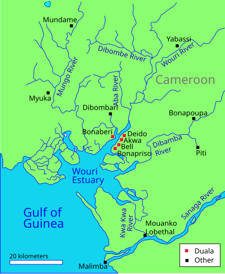
File:Wouri estuary 1850.svg
Appearance

Size of this PNG preview of this SVG file: 442 × 539 pixels. Other resolutions: 197 × 240 pixels | 394 × 480 pixels | 630 × 768 pixels | 840 × 1,024 pixels | 1,679 × 2,048 pixels.
Original file (SVG file, nominally 442 × 539 pixels, file size: 49 KB)
File history
Click on a date/time to view the file as it appeared at that time.
| Date/Time | Thumbnail | Dimensions | User | Comment | |
|---|---|---|---|---|---|
| current | 15:53, 22 February 2011 |  | 442 × 539 (49 KB) | Aymatth2 | Larger fonts |
| 20:14, 21 February 2011 |  | 442 × 539 (49 KB) | Aymatth2 | Label tweak | |
| 20:09, 21 February 2011 |  | 442 × 539 (49 KB) | Aymatth2 | Label fonts | |
| 16:19, 21 February 2011 |  | 442 × 539 (48 KB) | Aymatth2 | {{Information |Description ={{en|1=Sketch map of the Wouri estuary and rivers, illustrating Duala settlements around 1850}} |Source ={{own}} |Author =Aymatth2 |Date =2011-02-21 |Permission = |other_versio |
File usage
The following 7 pages use this file:
Global file usage
The following other wikis use this file:
- Usage on ca.wikipedia.org
- Usage on de.wikipedia.org
- Usage on es.wikipedia.org
- Usage on fr.wikipedia.org
- Usage on www.wikidata.org
- Usage on zh.wikipedia.org
