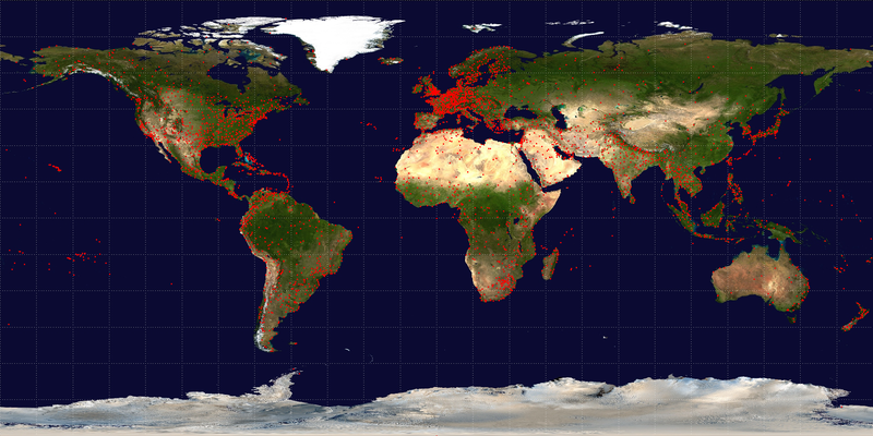
File:World-airport-map-2008.png
Appearance

Size of this preview: 800 × 400 pixels. Other resolutions: 320 × 160 pixels | 640 × 320 pixels | 1,024 × 513 pixels | 1,280 × 641 pixels | 2,048 × 1,025 pixels.
Original file (2,048 × 1,025 pixels, file size: 1.89 MB, MIME type: image/png)
File history
Click on a date/time to view the file as it appeared at that time.
| Date/Time | Thumbnail | Dimensions | User | Comment | |
|---|---|---|---|---|---|
| current | 07:06, 4 February 2009 |  | 2,048 × 1,025 (1.89 MB) | Jpatokal | {{Information |Description={{en|1=Map of airport distribution around the world. Base map is NASA Blue Marble (PD), airport data is from [http://openflights.org/data.html OpenFlights] (GNU Affero). }} |Source=Own work by uploader |Author=[[User:Jpatokal|J |
File usage
The following 2 pages use this file:
Global file usage
The following other wikis use this file:
- Usage on bh.wikipedia.org
- Usage on bn.wikipedia.org
- Usage on bs.wikipedia.org
- Usage on dz.wikipedia.org
- Usage on fa.wikipedia.org
- Usage on fr.wikipedia.org
- Usage on hak.wikipedia.org
- Usage on hu.wikipedia.org
- Usage on ja.wikipedia.org
- Usage on ko.wikipedia.org
- Usage on pa.wikipedia.org
- Usage on pt.wikipedia.org
- Usage on sh.wikipedia.org
- Usage on sk.wikipedia.org
- Usage on so.wikipedia.org
- Usage on sr.wikipedia.org
- Usage on test.wikipedia.org
- Usage on te.wikipedia.org
- Usage on th.wikipedia.org
- Usage on tr.wikipedia.org
- Usage on tt.wikipedia.org
- Usage on uk.wikipedia.org
- Usage on vi.wikipedia.org
- Usage on zh.wikipedia.org

