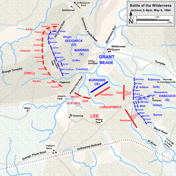
File:Wilderness May6 1400.png
Appearance

Size of this preview: 600 × 600 pixels. Other resolutions: 240 × 240 pixels | 480 × 480 pixels | 768 × 768 pixels | 1,024 × 1,024 pixels | 2,048 × 2,048 pixels | 5,000 × 5,000 pixels.
Original file (5,000 × 5,000 pixels, file size: 4.48 MB, MIME type: image/png)
File history
Click on a date/time to view the file as it appeared at that time.
| Date/Time | Thumbnail | Dimensions | User | Comment | |
|---|---|---|---|---|---|
| current | 21:37, 16 October 2015 |  | 5,000 × 5,000 (4.48 MB) | Hlj | Fix typos and make minor graphical improvements. Same license. |
| 20:04, 17 March 2011 |  | 2,500 × 2,500 (1.94 MB) | Hlj | Minor graphical changes to conform to new ACW map style for roads and rivers. Same license. | |
| 01:47, 23 October 2010 |  | 2,500 × 2,500 (1.73 MB) | Hlj | Corrected some Confederate troop positions and movements. Same license. | |
| 00:58, 21 October 2010 |  | 2,500 × 2,500 (1.73 MB) | Hlj | {{Information |Description={{en|1=Map of a portion of the Battle of the Wilderness of the American Civil War. Drawn in Adobe Illustrator CS5 by Hal Jespersen. Graphic source file is available at http://www.posix.com/CWmaps/ {{cc-by-3.0|Map by Hal |
File usage
The following 2 pages use this file:
Global file usage
The following other wikis use this file:
- Usage on de.wikipedia.org
- Usage on es.wikipedia.org
- Usage on hu.wikipedia.org
- Usage on hy.wikipedia.org
- Usage on nl.wikipedia.org
