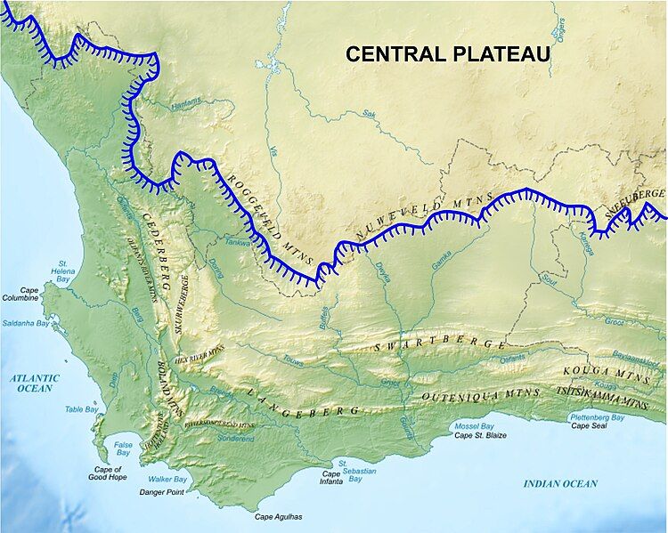
File:Western Cape Topology.jpg
Appearance

Size of this preview: 750 × 599 pixels. Other resolutions: 300 × 240 pixels | 601 × 480 pixels | 961 × 768 pixels | 1,280 × 1,023 pixels | 1,498 × 1,197 pixels.
Original file (1,498 × 1,197 pixels, file size: 930 KB, MIME type: image/jpeg)
File history
Click on a date/time to view the file as it appeared at that time.
| Date/Time | Thumbnail | Dimensions | User | Comment | |
|---|---|---|---|---|---|
| current | 06:35, 10 March 2016 |  | 1,498 × 1,197 (930 KB) | Oggmus | The central area had been incorrectly labeled the "Central Escarpment" when it should have been "Central Plateau" |
| 18:01, 5 June 2015 |  | 8,000 × 6,364 (9.65 MB) | Oggmus | Made the escarpment diagrammatically more obvious than just a blue line | |
| 10:34, 24 May 2014 |  | 7,326 × 5,838 (3.07 MB) | Oggmus | User created page with UploadWizard |
File usage
The following 2 pages use this file:
Global file usage
The following other wikis use this file:
- Usage on cs.wikipedia.org
- Usage on de.wikipedia.org
- Usage on es.wikipedia.org
- Usage on nl.wikipedia.org
- Usage on pl.wikipedia.org
- Usage on ru.wikipedia.org
- Usage on sw.wikipedia.org
- Usage on ur.wikipedia.org
- Usage on zh.wikipedia.org

