File:Waterloo 631.jpg
Page contents not supported in other languages.
Tools
Actions
General
In other projects
Appearance

Size of this preview: 800 × 478 pixels. Other resolutions: 320 × 191 pixels | 640 × 383 pixels | 1,024 × 612 pixels | 1,280 × 765 pixels | 3,264 × 1,952 pixels.
Original file (3,264 × 1,952 pixels, file size: 1.91 MB, MIME type: image/jpeg)
| This is a file from the Wikimedia Commons. Information from its description page there is shown below. Commons is a freely licensed media file repository. You can help. |
Summary
| DescriptionWaterloo 631.jpg |
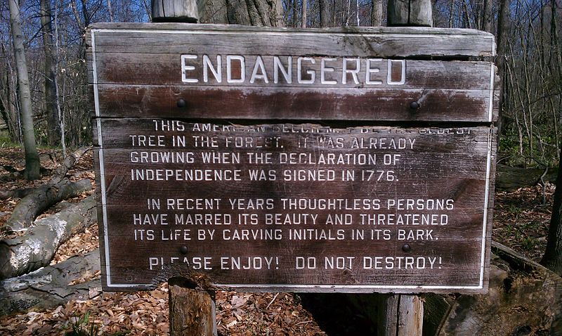
English: Sign reads: "ENDANGERED This American Beech may be the oldest tree in the forest. It was already growing when the Declaration of Independence was signed in 1776. In recent years thoughtless persons have marred its beauty and threatened its life by carving initials in its bark. Please enjoy! Do not destroy!" See File:Waterloo 635.jpg for the tree marked by this sign. |
| Date | |
| Source | Own work |
| Author | cmadler |
| Camera location | 42° 19′ 27.02″ N, 84° 04′ 54.88″ W | View this and other nearby images on: OpenStreetMap |
|---|
| Upload method |
|---|
Licensing
I, the copyright holder of this work, hereby publish it under the following licenses:
This file is licensed under the Creative Commons Attribution-Share Alike 3.0 Unported license.
- You are free:
- to share – to copy, distribute and transmit the work
- to remix – to adapt the work
- Under the following conditions:
- attribution – You must give appropriate credit, provide a link to the license, and indicate if changes were made. You may do so in any reasonable manner, but not in any way that suggests the licensor endorses you or your use.
- share alike – If you remix, transform, or build upon the material, you must distribute your contributions under the same or compatible license as the original.

|
Permission is granted to copy, distribute and/or modify this document under the terms of the GNU Free Documentation License, Version 1.2 or any later version published by the Free Software Foundation; with no Invariant Sections, no Front-Cover Texts, and no Back-Cover Texts. A copy of the license is included in the section entitled GNU Free Documentation License.http://www.gnu.org/copyleft/fdl.htmlGFDLGNU Free Documentation Licensetruetrue |
You may select the license of your choice.
Captions
Add a one-line explanation of what this file represents
Items portrayed in this file
depicts
2 April 2012
42°19'27.019"N, 84°4'54.880"W
111
4.92 millimetre
1,997,804 byte
1,952 pixel
3,264 pixel
image/jpeg
d9633b54674918b0ae0ff3bc78a4ab714bd3b4c2
File history
Click on a date/time to view the file as it appeared at that time.
| Date/Time | Thumbnail | Dimensions | User | Comment | |
|---|---|---|---|---|---|
| current | 23:09, 2 April 2012 |  | 3,264 × 1,952 (1.91 MB) | Cmadler |
File usage
The following page uses this file:
Metadata
This file contains additional information, probably added from the digital camera or scanner used to create or digitize it.
If the file has been modified from its original state, some details may not fully reflect the modified file.
| Camera manufacturer | HTC |
|---|---|
| Camera model | PC36100 |
| ISO speed rating | 111 |
| Date and time of data generation | 15:22, 2 April 2012 |
| Lens focal length | 4.92 mm |
| Latitude | 42° 19′ 27.02″ N |
| Longitude | 84° 4′ 54.88″ W |
| Altitude | 258 meters above sea level |
| Horizontal resolution | 72 dpi |
| Vertical resolution | 72 dpi |
| Y and C positioning | Centered |
| Exif version | 2.2 |
| Date and time of digitizing | 15:22, 2 April 2012 |
| Meaning of each component |
|
| Supported Flashpix version | 1 |
| Color space | sRGB |
| GPS time (atomic clock) | 19:22 |
| Geodetic survey data used | WGS-84 |
| GPS date | 2 April 2012 |
| GPS tag version | 2.2.0 |
Retrieved from "https://en.wikipedia.org/wiki/File:Waterloo_631.jpg"
