Jump to content

File:Washington flood novembre 2021.jpg

Page contents not supported in other languages.
This is a file from the Wikimedia Commons
From Wikipedia, the free encyclopedia

Washington_flood_novembre_2021.jpg (720 × 519 pixels, file size: 186 KB, MIME type: image/jpeg)

Summary

Description
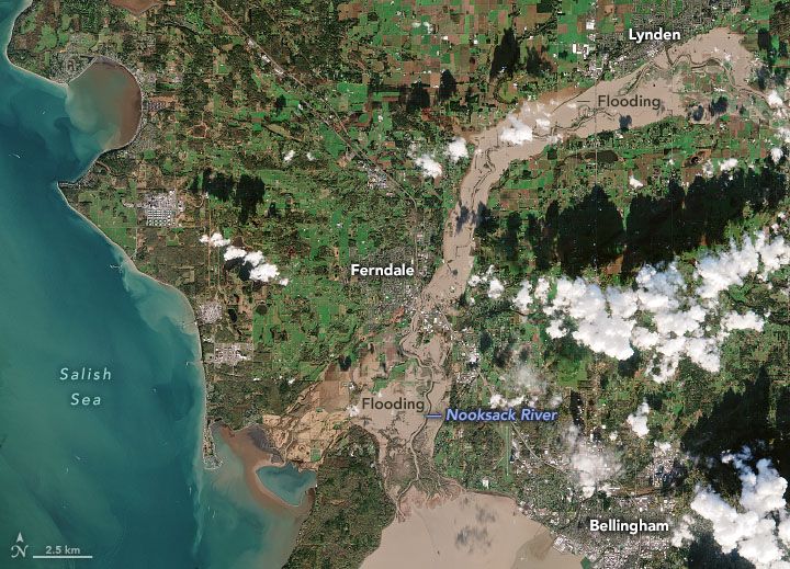
Français : Les inondations le long du fleuve Nooksack, État de Washington, sont visibles sur cette image en couleurs naturelles, acquise le 16 novembre 2021 par la mission Copernicus Sentinel-2 de l'Agence spatiale européenne. Ce jour-là, la rivière culminait à 7,24 mètres (23,76 pieds), soit moins que la crête la plus élevée jamais enregistrée (31,23 pieds en février 1951) mais toujours plus élevée que la rivière n'a augmenté depuis des décennies. De Lynden à Ferndale jusqu'à l'embouchure du fleuve dans la baie de Bellingham, les eaux de crue ont inondé les quartiers, les entreprises et les terres agricoles. Dans le comté de Whatcom, 500 personnes ont évacué leurs maisons.
English: Flooding along Washington’s Nooksack River is visible in this natural-color image, acquired on November 16, 2021, by the European Space Agency’s Copernicus Sentinel-2 mission. On this day, the river crested at 7.24 meters (23.76 feet), short of the highest crest on record (31.23 feet in February 1951) but still higher than the river has risen in decades. From Lynden to Ferndale to the mouth of the river at Bellingham Bay, floodwaters inundated neighborhoods, businesses, and farmland. In Whatcom County, 500 people evacuated their homes.
Date
Source https://earthobservatory.nasa.gov/images/149100/severe-flooding-in-the-pacific-northwest
Author NASA Earth Observatory

Licensing

Public domain This file is in the public domain in the United States because it was solely created by NASA. NASA copyright policy states that "NASA material is not protected by copyright unless noted". (See Template:PD-USGov, NASA copyright policy page or JPL Image Use Policy.)
Warnings:

Captions

Novembre 2021 flood in Washington State

Items portrayed in this file

depicts

18 November 2021

image/jpeg

File history

Click on a date/time to view the file as it appeared at that time.

Date/TimeThumbnailDimensionsUserComment
current04:49, 22 December 2021Thumbnail for version as of 04:49, 22 December 2021720 × 519 (186 KB)Pierre cbZoom on the region of interest
04:47, 22 December 2021Thumbnail for version as of 04:47, 22 December 202110,980 × 10,980 (25.19 MB)Pierre cbUploaded a work by NASA Earth Observatory from https://earthobservatory.nasa.gov/images/149100/severe-flooding-in-the-pacific-northwest with UploadWizard

The following page uses this file:

Global file usage

The following other wikis use this file:

Metadata