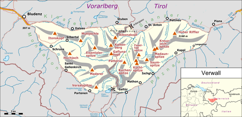
File:Verwall Karte.png
Appearance

Size of this preview: 800 × 388 pixels. Other resolutions: 320 × 155 pixels | 640 × 310 pixels | 1,024 × 496 pixels | 1,280 × 620 pixels | 2,863 × 1,387 pixels.
Original file (2,863 × 1,387 pixels, file size: 1.13 MB, MIME type: image/png)
File history
Click on a date/time to view the file as it appeared at that time.
| Date/Time | Thumbnail | Dimensions | User | Comment | |
|---|---|---|---|---|---|
| current | 17:04, 25 March 2018 |  | 2,863 × 1,387 (1.13 MB) | Pechristener | fix of Montafon |
| 17:02, 25 March 2018 |  | 2,863 × 1,387 (1.13 MB) | Pechristener | inner-austrian border smaller | |
| 16:58, 25 March 2018 |  | 2,863 × 1,387 (1.13 MB) | Pechristener | .. there was a misshapen with the location map | |
| 16:56, 25 March 2018 |  | 2,863 × 1,387 (1.14 MB) | Pechristener | {{Map |Description={{de|1=Lagekarte des de:Verwalls}} |Source ={{own}} Map was created using: *[http://www.openstreetmap.org/ Open Street Map] *{{f|Austria location map.svg}} for location map |Author = *Pechristener *{{f|Austria location map.svg}}: NordNordWest, {{u|Lencer}} |Date =2018-03-25 |Permission =Map data (c) OpenStreetMap (and) contributors, CC-BY-SA |other_versions = }} {{cc-by-sa-2.0}} {{ODbL}} Category:Topographic maps of Austria Category:Verwall Category:Files by User:FkMohr/Karte Category:Files by User:Pechristener/Karten/Alpen |
File usage
The following page uses this file:
Global file usage
The following other wikis use this file:
- Usage on als.wikipedia.org
- Usage on de.wikipedia.org
- Usage on fr.wikipedia.org
- Usage on it.wikipedia.org
- Usage on ro.wikipedia.org
- Usage on www.wikidata.org

