Jump to content

File:Turbulent Tropical Skies.jpg

Page contents not supported in other languages.
This is a file from the Wikimedia Commons
From Wikipedia, the free encyclopedia

Original file (12,000 × 12,000 pixels, file size: 20.37 MB, MIME type: image/jpeg)

Summary

Description

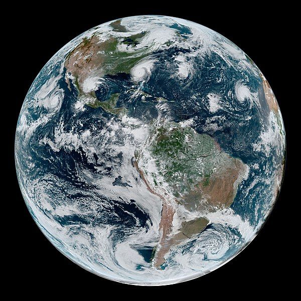
On September 4, 2019, a loose chain of tropical cyclones lined up across the Western Hemisphere. At the time of this image (17:10 Universal Time) Hurricane Juliette in the East Pacific and Hurricane Dorian in the Atlantic were both category 2 storms.

Meanwhile, Tropical Storm Fernand packed sustained winds of 45 miles (75 kilometers) per hour and had just recently made landfall over northeastern Mexico. Gabrielle strengthened into a tropical storm on September 4 over the eastern Atlantic, and had sustained winds of 50 miles (85 kilometers) around the time of this image.

Data for the simulated natural-color image were acquired with the Advanced Baseline Imager (ABI) on the Geostationary Operational Environmental Satellite 16. GOES-16 is operated by the National Oceanic and Atmospheric Administration (NOAA); NASA helps develop and launch the GOES series of satellites.
Date
Source https://earthobservatory.nasa.gov/images/145563/turbulent-tropical-skies
Author NASA Earth Observatory image by Joshua Stevens, using GOES 16 imagery courtesy of NOAA and the National Environmental Satellite, Data, and Information Service (NESDIS). Caption by Kathryn Hansen.
Warning The original file is very high-resolution. It might not load properly or could cause your browser to freeze when opened at full size. Open in ZoomViewer

Assessment

Picture of the year
Picture of the year
Featured picture

Wikimedia Commons

This file was a finalist in Picture of the Year 2021.
This is a featured picture on Wikimedia Commons (Featured pictures) and is considered one of the finest images. See its nomination here.

If you have an image of similar quality that can be published under a suitable copyright license, be sure to upload it, tag it, and nominate it.

Licensing

Public domain This file is in the public domain in the United States because it was solely created by NASA. NASA copyright policy states that "NASA material is not protected by copyright unless noted". (See Template:PD-USGov, NASA copyright policy page or JPL Image Use Policy.)
Warnings:

Captions

a loose chain of tropical cyclones lined up across the Western Hemisphere

Items portrayed in this file

depicts

4 September 2019

image/jpeg

File history

Click on a date/time to view the file as it appeared at that time.

Date/TimeThumbnailDimensionsUserComment
current17:48, 1 February 2021Thumbnail for version as of 17:48, 1 February 202112,000 × 12,000 (20.37 MB)StellarHalo{{Information |Description=On September 4, 2019, a loose chain of tropical cyclones lined up across the Western Hemisphere. At the time of this image (17:10 Universal Time) Hurricane Juliette in the East Pacific and Hurricane Dorian in the Atlantic were both category 2 storms. Meanwhile, Tropical Storm Fernand packed sustained winds of 45 miles (75 kilometers) per hour and had just recently made landfall over northeastern Mexico. Gabrielle strengthened into a tropical storm on September 4 ov...

The following 2 pages use this file:

Global file usage

Metadata