File:Tasman Peninlsula map.png
Appearance
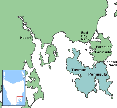
Tasman_Peninlsula_map.png (395 × 367 pixels, file size: 28 KB, MIME type: image/png)
File history
Click on a date/time to view the file as it appeared at that time.
| Date/Time | Thumbnail | Dimensions | User | Comment | |
|---|---|---|---|---|---|
| current | 21:36, 4 February 2011 |  | 395 × 367 (28 KB) | Maproom | Saved file THEN moved "Neck" names to correct positions. |
| 21:34, 4 February 2011 |  | 395 × 367 (28 KB) | Maproom | Moved "Neck" names to correct positions | |
| 21:28, 4 February 2011 |  | 395 × 367 (28 KB) | Maproom | Used shading to distinguish Tasman Peninsula only. Moved Hobart to correct place. Added more names: Forestier Peninsula, East Bay Neck, Eaglehawk Neck. | |
| 02:29, 4 April 2009 |  | 395 × 367 (30 KB) | Pauk | {{Information |Description={{en|1=Tasman Peninlsula}} |Source=http://en.wikipedia.org/wiki/File:Tasman_Peninlsula_map.png |Author=Ghostieguide |Date=2006-07-04 |Permission= |other_versions= }} {{GFDL}} <!--{{ImageUpload|full}}--> Category:Tasmania |
File usage
The following 2 pages use this file:
Global file usage
The following other wikis use this file:
- Usage on az.wikipedia.org
- Usage on be-tarask.wikipedia.org
- Usage on be.wikipedia.org
- Usage on cs.wikipedia.org
- Usage on eo.wikipedia.org
- Usage on es.wikipedia.org
- Usage on fr.wikipedia.org
- Usage on id.wikipedia.org
- Usage on ja.wikipedia.org
- Usage on pl.wikipedia.org
- Usage on pt.wikipedia.org
- Usage on ru.wikipedia.org


