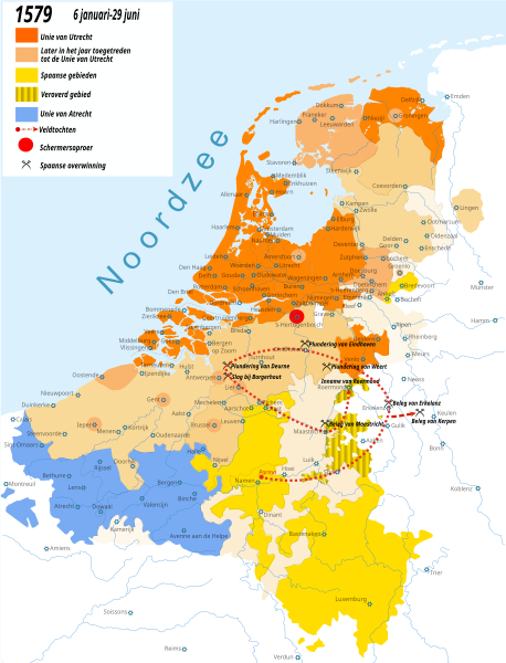
File:Tachtigjarige oorlog-1579.svg
Appearance

Size of this PNG preview of this SVG file: 458 × 600 pixels. Other resolutions: 183 × 240 pixels | 366 × 480 pixels | 586 × 768 pixels | 782 × 1,024 pixels | 1,564 × 2,048 pixels | 1,651 × 2,162 pixels.
Original file (SVG file, nominally 1,651 × 2,162 pixels, file size: 899 KB)
File history
Click on a date/time to view the file as it appeared at that time.
| Date/Time | Thumbnail | Dimensions | User | Comment | |
|---|---|---|---|---|---|
| current | 15:12, 16 July 2022 |  | 1,651 × 2,162 (899 KB) | Nederlandse Leeuw | Corrected the location of some towns in the south such as Doornik/Tournai, Namen/Namur, Dowaai/Douai, Dinant, Luxemburg, Hoei/Huy etc.. This seems to be a problem in all .svg maps of Henk B. |
| 16:31, 30 May 2022 |  | 1,651 × 2,162 (900 KB) | Nederlandse Leeuw | Cambrésis coloured light beige. It was in the HRE but not in the Habsburg Netherlands, nor the Union of Arras. | |
| 16:26, 10 August 2013 |  | 1,651 × 2,162 (900 KB) | Henk B. | Reverted to version as of 08:13, 6 August 2013 | |
| 16:11, 10 August 2013 |  | 1,651 × 2,162 (914 KB) | Henk B. | -roermond | |
| 16:03, 10 August 2013 |  | 1,651 × 2,162 (914 KB) | Henk B. | another update | |
| 08:13, 6 August 2013 |  | 1,651 × 2,162 (900 KB) | Henk B. | legenda | |
| 06:17, 6 August 2013 |  | 1,651 × 2,162 (900 KB) | Henk B. | update | |
| 19:20, 16 July 2013 |  | 1,651 × 2,162 (630 KB) | Henk B. | == {{int:filedesc}} == {{Information |Description=Krijgsbewegingen in de Tachtigjarige Oorlog. 1579. {{es|Situación de los Países Bajos en 1579, durante la guerra de Flandes. En rojo el territorio bajo dominio de las Provincias Unidas; en marrón cl... |
File usage
The following 3 pages use this file:
Global file usage
The following other wikis use this file:


