Jump to content

File:St.-Jacob-Church.jpg

Page contents not supported in other languages.
This is a file from the Wikimedia Commons
From Wikipedia, the free encyclopedia

Original file (2,689 × 3,283 pixels, file size: 5.2 MB, MIME type: image/jpeg)

Description
  
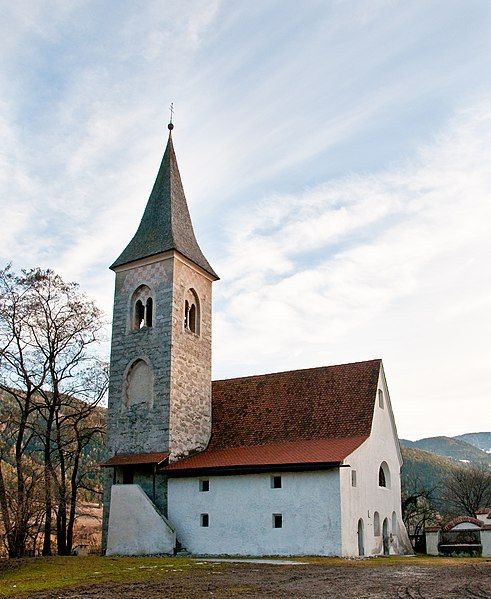
This media shows the cultural heritage monument with the number 14305 in South Tyrol.
(Wikidata)

St. Jakob in der Mahr: the small church was mentioned for the first time in 1173. It was consecrated in 1428 to the patron of the pilgrims. On the inside, the artistic decor is remarkable: in the vault the lamb God, surrounded by 16 arms, such as Brixen, Kärnten, Austria and many local aristocratic families. The representation of the legend of Jakob in the choir is from the painter- school of Master Leonhard von Brixen.


Chiesa di San Giacomo: documentata già nel 1173, fu riedificata in stile gotico dopo il 1400.
Date
Source originally posted to Flickr as St.-Jacob-Church
Author Michele Bighignoli
Permission
(Reusing this file)
This image, which was originally posted to Flickr, was uploaded to Commons using Flickr upload bot on 5 March 2010, 07:59 by Pauk. On that date, it was confirmed to be licensed under the terms of the license indicated.
w:en:Creative Commons
attribution share alike
This file is licensed under the Creative Commons Attribution-Share Alike 2.0 Generic license.
You are free:
  • to share – to copy, distribute and transmit the work
  • to remix – to adapt the work
Under the following conditions:
  • attribution – You must give appropriate credit, provide a link to the license, and indicate if changes were made. You may do so in any reasonable manner, but not in any way that suggests the licensor endorses you or your use.
  • share alike – If you remix, transform, or build upon the material, you must distribute your contributions under the same or compatible license as the original.
Object location46° 41′ 34.03″ N, 11° 38′ 22.27″ E Kartographer map based on OpenStreetMap.View this and other nearby images on: OpenStreetMapinfo

Captions

Add a one-line explanation of what this file represents

Items portrayed in this file

depicts

27 February 2010

46°41'34.026"N, 11°38'22.272"E

File history

Click on a date/time to view the file as it appeared at that time.

Date/TimeThumbnailDimensionsUserComment
current07:59, 5 March 2010Thumbnail for version as of 07:59, 5 March 20102,689 × 3,283 (5.2 MB)Flickr upload botUploaded from http://flickr.com/photo/29937169@N02/4405015644 using Flickr upload bot

The following page uses this file:

Global file usage

The following other wikis use this file:

Metadata