Jump to content

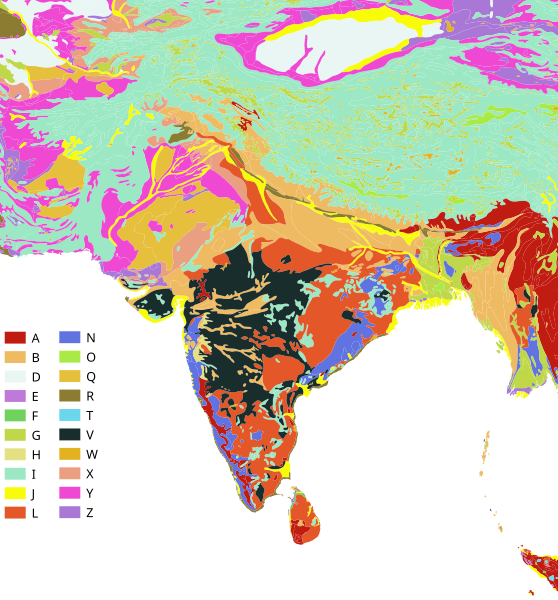
File:South Asia Soil.svg

Page contents not supported in other languages.
This is a file from the Wikimedia Commons
From Wikipedia, the free encyclopedia

Original file (SVG file, nominally 705 × 757 pixels, file size: 8.06 MB)

Summary

Description

Map of Dominant Soil type for the South Asian region - extracted from Digital Soil Map of the World - based on FAO-UNESCO Soil Map of the World

Key to codes: A : Acrisols B : Cambisols C : Chernozems D : Podzoluvisols E : Rendzinas F : Ferralsols G : Gleysols H : Phaeozems I : Lithosols J : Fluvisols K : Kastanozems L : Luvisols M : Greyzems N : Nitosols O : Histosols P : Podzols Q : Arenosols R : Regosols S : Solonetz T : Andosols U : Rankers W : Planosols X : Xerosols Y : Yermosols Z : Solonchaks
Date
Source Original data FAO-UNESCO Soil Map of the World from https://data.apps.fao.org/map/catalog/srv/eng/catalog.search#/metadata/446ed430-8383-11db-b9b2-000d939bc5d8 - Accessed September 2023. The original data was published in 10 volumes and 19 map sheets, from 1972 to 1977. The SVG map rendering, colour choice and layout are the work of Shyamal.
Author Data from United Nations, Land and Water Development Division, FAO, Rome in collaboration with UNESCO. QGIS derivative map created by Shyamal
Permission
(Reusing this file)

w:en:Creative Commons
attribution
This file is licensed under the Creative Commons Attribution 4.0 International license.
You are free:
  • to share – to copy, distribute and transmit the work
  • to remix – to adapt the work
Under the following conditions:
  • attribution – You must give appropriate credit, provide a link to the license, and indicate if changes were made. You may do so in any reasonable manner, but not in any way that suggests the licensor endorses you or your use.

Captions

Add a one-line explanation of what this file represents

Items portrayed in this file

depicts

image/svg+xml

424c9b55c17430f2a5fc369752ebb9eb15ebe9f7

8,446,610 byte

757 pixel

705 pixel

File history

Click on a date/time to view the file as it appeared at that time.

Date/TimeThumbnailDimensionsUserComment
current16:37, 6 September 2023Thumbnail for version as of 16:37, 6 September 2023705 × 757 (8.06 MB)ShyamalRemove outlines
16:04, 6 September 2023Thumbnail for version as of 16:04, 6 September 2023705 × 757 (8.11 MB)Shyamal{{Information |Description=Map of Dominant Soil type for the South Asian region - extracted from Digital Soil Map of the World - based on FAO-UNESCO Soil Map of the World Key to codes: A : ACRISOLS B : CAMBISOLS C : CHERNOZEMS D : PODZOLUVISOLS E : RENDZINAS F : FERRALSOLS G : GLEYSOLS H : PHAEOZEMS I : LITHOSOLS J : FLUVISOLS K : KASTANOZEMS L : LUVISOLS M : GREYZEMS N : NITOSOLS O : HISTOSOLS P : PODZOLS Q : ARENOSOLS R : REGOSOLS S : SOLONETZ T : ANDOSOLS U : RANKERS W : PLANOSOLS X : XER...

The following page uses this file:

Metadata