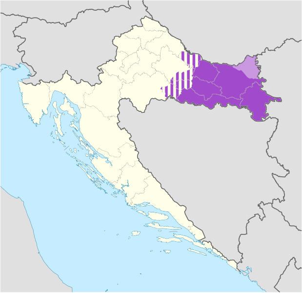
File:Slavonia.svg
Appearance

Size of this PNG preview of this SVG file: 619 × 599 pixels. Other resolutions: 248 × 240 pixels | 496 × 480 pixels | 793 × 768 pixels | 1,058 × 1,024 pixels | 2,115 × 2,048 pixels | 1,098 × 1,063 pixels.
Original file (SVG file, nominally 1,098 × 1,063 pixels, file size: 798 KB)
File history
Click on a date/time to view the file as it appeared at that time.
| Date/Time | Thumbnail | Dimensions | User | Comment | |
|---|---|---|---|---|---|
| current | 10:17, 19 July 2020 |  | 1,098 × 1,063 (798 KB) | Koreanovsky | When we talk about modern-day Slavonia, we usually refer to the region that is colored in dark purple. There is no exact definition, since those regions are historical and do not have any official status, but mostly we do not include those parts that are striped, such as in the region of small Moslavina. |
| 18:28, 7 June 2014 |  | 1,098 × 1,063 (751 KB) | DIREKTOR | Fixed borders, removed a number of issues. | |
| 10:49, 7 June 2014 |  | 1,098 × 1,063 (798 KB) | DIREKTOR | Corrections. | |
| 09:09, 7 June 2014 |  | 1,098 × 1,063 (798 KB) | DIREKTOR | Small fix. | |
| 07:30, 7 June 2014 |  | 1,098 × 1,063 (799 KB) | DIREKTOR | Small-scale modifications. | |
| 11:58, 6 June 2014 |  | 512 × 496 (268 KB) | DIREKTOR | Colours | |
| 11:12, 7 March 2012 |  | 1,098 × 1,063 (440 KB) | Tomobe03 |
File usage
The following 3 pages use this file:
Global file usage
The following other wikis use this file:
- Usage on ar.wikipedia.org
- Usage on bg.wikipedia.org
- Usage on br.wikipedia.org
- Usage on bs.wikipedia.org
- Usage on ca.wikipedia.org
- Usage on de.wikipedia.org
- Usage on de.wikivoyage.org
- Usage on de.wiktionary.org
- Usage on eo.wikipedia.org
- Usage on es.wikipedia.org
- Usage on et.wikipedia.org
- Usage on eu.wikipedia.org
- Usage on fa.wikipedia.org
- Usage on hr.wikipedia.org
- Usage on hu.wikipedia.org
- Usage on it.wikivoyage.org
- Usage on kk.wikipedia.org
- Usage on ko.wikipedia.org
- Usage on la.wikipedia.org
- Usage on li.wikipedia.org
- Usage on lv.wikipedia.org
- Usage on mzn.wikipedia.org
- Usage on pl.wikipedia.org
- Usage on pl.wikivoyage.org
- Usage on ru.wikipedia.org
- Usage on ru.wikivoyage.org
- Usage on sh.wikipedia.org
- Usage on sr.wikipedia.org
- Usage on sv.wikipedia.org
- Usage on uk.wikipedia.org
- Usage on ur.wikipedia.org
- Usage on www.wikidata.org
- Usage on zh.wikipedia.org
