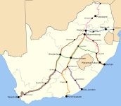
File:Shosholoza Meyl routes 2012.svg
Appearance

Size of this PNG preview of this SVG file: 687 × 600 pixels. Other resolutions: 275 × 240 pixels | 550 × 480 pixels | 880 × 768 pixels | 1,173 × 1,024 pixels | 2,346 × 2,048 pixels | 1,070 × 934 pixels.
Original file (SVG file, nominally 1,070 × 934 pixels, file size: 321 KB)
File history
Click on a date/time to view the file as it appeared at that time.
| Date/Time | Thumbnail | Dimensions | User | Comment | |
|---|---|---|---|---|---|
| current | 17:00, 17 December 2012 |  | 1,070 × 934 (321 KB) | Htonl | new routes |
| 18:26, 23 June 2012 |  | 1,070 × 934 (331 KB) | Htonl | further tweak | |
| 18:21, 23 June 2012 |  | 1,070 × 934 (331 KB) | Htonl | tweak | |
| 17:16, 23 June 2012 |  | 1,070 × 934 (331 KB) | Htonl | {{Information |Description ={{en|1=Map showing the route network of the Shosholoza Meyl intercity passenger rail service in South Africa, as of June 2012.}} |Source ={{own}}, based on [[:File:South Africa rail networ... |
File usage
The following page uses this file:
Global file usage
The following other wikis use this file:
- Usage on ast.wikipedia.org
- Usage on bn.wikivoyage.org
- Usage on de.wikipedia.org
- Usage on en.wikivoyage.org
- Usage on es.wikipedia.org
- Usage on fr.wikipedia.org
- Usage on he.wikivoyage.org
- Usage on it.wikivoyage.org
- Usage on ja.wikipedia.org
- Usage on no.wikipedia.org
- Usage on zh.wikipedia.org

