Jump to content

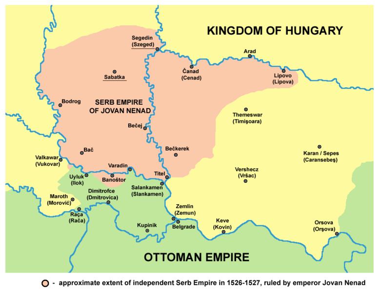
File:Serbian empire06 map.png

Page contents not supported in other languages.
This is a file from the Wikimedia Commons
From Wikipedia, the free encyclopedia

Original file (984 × 759 pixels, file size: 74 KB, MIME type: image/png)

Summary

Description
English: historical map showing Serb Empire of Jovan Nenad in 1526-1527, English language version.
Српски / srpski: историјска мапа која приказује Српско царство Јована Ненада 1526-1527. године, верзија на енглеском језику.
Date 9 February 2009 (original upload date)
Source No machine-readable source provided. Own work assumed (based on copyright claims).
Author No machine-readable author provided. WikiEditor2004 assumed (based on copyright claims).

References

  • Veselin P. Dželetović, Poslednji srpski car - Jovan Nenad, Poeta - Beograd, 2007.
  • Dr Aleksa Ivić, Istorija Srba u Vojvodini, Novi Sad, 1929.
  • Milan Tutorov, Mala Raška a u Banatu, Zrenjanin, 1991.
  • Drago Njegovan, Prisajedinjenje Vojvodine Srbiji, Novi Sad, 2004.
  • Dr. Dušan J. Popović, Srbi u Vojvodini, knjiga 1, Novi Sad, 1990.
  • Peter Rokai, Zoltan Đere, Tibor Pal, Aleksandar Kasaš, Istorija Mađara, Beograd, 2002.
  • Vladimir Ćorović, Ilustrovana istorija Srba, knjiga četvrta, Beograd, 2006.
  • Dr Milenko Palić, Srbi u Mađarskoj - Ugarskoj do 1918, Novi Sad, 1995.
  • The Times History of Europe, Times Books, 2002.

Source and licence

self made map by WikiEditor2004

Licensing

Public domain I, the copyright holder of this work, release this work into the public domain. This applies worldwide.
In some countries this may not be legally possible; if so:
I grant anyone the right to use this work for any purpose, without any conditions, unless such conditions are required by law.

Captions

Add a one-line explanation of what this file represents

Items portrayed in this file

depicts

9 February 2009

75,842 byte

759 pixel

984 pixel

image/png

00e01932a59b36415ae084e95f18f5abef9e8066

File history

Click on a date/time to view the file as it appeared at that time.

Date/TimeThumbnailDimensionsUserComment
current16:57, 14 April 2015Thumbnail for version as of 16:57, 14 April 2015984 × 759 (74 KB)WikiEditor2004corrections
14:54, 29 November 2014Thumbnail for version as of 14:54, 29 November 2014984 × 759 (74 KB)WikiEditor2004aesthetics
14:54, 9 November 2011Thumbnail for version as of 14:54, 9 November 2011982 × 759 (74 KB)WikiEditor2004few corrections: Ilok and Rača were Ottoman, Sotin was controlled by Jovan Nenad
12:11, 12 July 2009Thumbnail for version as of 12:11, 12 July 2009982 × 759 (70 KB)WikiEditor2004
20:06, 16 March 2009Thumbnail for version as of 20:06, 16 March 2009545 × 452 (43 KB)WikiEditor2004
23:49, 9 February 2009Thumbnail for version as of 23:49, 9 February 2009632 × 555 (59 KB)WikiEditor2004historical map of empire of Jovan Nenad - English version (self made) {{PD-self}} Category:Maps of the history of Vojvodina Category:Maps of the history of Serbia

The following 4 pages use this file:

Global file usage

The following other wikis use this file: