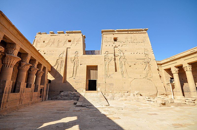
File:Second Pylon (14284182329).jpg

Original file (4,198 × 2,788 pixels, file size: 1.07 MB, MIME type: image/jpeg)
| This is a file from the Wikimedia Commons. Information from its description page there is shown below. Commons is a freely licensed media file repository. You can help. |
Summary
| DescriptionSecond Pylon (14284182329).jpg |
The northern wall of the forecourt is formed by the second Great Pylon which stands 105 feet wide and 40 feet tall. It is set at a different angle than the first Pylon. An incline plane of shallow steps leads to the gateway between the towers. On the left, or western tower, Ptolemy XII offers incense and dedicates sacrificial animals to Horus, Hathor and other gods. Above this are two small reliefs, horribly mutilated, depicting this king presenting a wreath to Horus and Nephthys and offering incense and pouring water on an altar in the presence of Osiris, Isis and Horus. On the right, or eastern tower, there are similar scenes but in a much better state of preservation. After the murder of his father, Osiris, Horus grew to manhood and overthrew the enemies of his father. Horus, as Pharaoh of Egypt, became the ancestor of all succeeding kings. It was therefore essential that each pharaoh on his accession should be recognized as a true descendant of Horus. At the base of the eastern tower, part of the granite foundation of the original island protruded and this was carved into a stele on which Ptolemy VI Philometor, and his queen Cleopatra II stand before Isis and Horus. This stela was faithfully transferred to the new island with the rest of the temple. An inscription refers to the grant of the Dodekaschoinoi made to Isis, which brought the priests of Philae into parity with those of Elephantine. Dodekaschoinoi is a Greek word for "twelve schoinoi" A schoinos equaled about seven miles. It is not a measurement of area, but rather length, so presumably this meant that their foundation estate to finance the temple extended for about seven miles along the Nile River, including the arable land. www.touregypt.net |
| Date | |
| Source | Second Pylon |
| Author | Jorge Láscar from Melbourne, Australia |
| Camera location | 24° 01′ 31.92″ N, 32° 53′ 02.55″ E | View this and other nearby images on: OpenStreetMap |
|---|
Licensing
- You are free:
- to share – to copy, distribute and transmit the work
- to remix – to adapt the work
- Under the following conditions:
- attribution – You must give appropriate credit, provide a link to the license, and indicate if changes were made. You may do so in any reasonable manner, but not in any way that suggests the licensor endorses you or your use.
| This image was originally posted to Flickr by Jorge Lascar at https://flickr.com/photos/8721758@N06/14284182329 (archive). It was reviewed on 9 February 2018 by FlickreviewR 2 and was confirmed to be licensed under the terms of the cc-by-2.0. |
9 February 2018
Captions
Items portrayed in this file
depicts
some value
13 September 2012
24°1'31.922"N, 32°53'2.555"E
File history
Click on a date/time to view the file as it appeared at that time.
| Date/Time | Thumbnail | Dimensions | User | Comment | |
|---|---|---|---|---|---|
| current | 10:50, 9 February 2018 |  | 4,198 × 2,788 (1.07 MB) | Thesupermat2 | Transferred from Flickr via Flickr2Commons |
File usage
The following page uses this file:
Global file usage
The following other wikis use this file:
- Usage on ko.wikipedia.org
Metadata
This file contains additional information, probably added from the digital camera or scanner used to create or digitize it.
If the file has been modified from its original state, some details may not fully reflect the modified file.
| Camera manufacturer | NIKON CORPORATION |
|---|---|
| Camera model | NIKON D90 |
| Exposure time | 1/320 sec (0.003125) |
| F-number | f/9 |
| ISO speed rating | 200 |
| Date and time of data generation | 16:01, 13 September 2012 |
| Lens focal length | 11 mm |
| Horizontal resolution | 240 dpi |
| Vertical resolution | 240 dpi |
| Software used | Adobe Photoshop Lightroom 5.3 (Macintosh) |
| File change date and time | 09:48, 21 June 2014 |
| Exposure Program | Not defined |
| Exif version | 2.3 |
| Date and time of digitizing | 16:01, 13 September 2012 |
| Shutter speed | 8.321928 |
| APEX aperture | 6.33985 |
| Exposure bias | 0 |
| Maximum land aperture | 4.1 APEX (f/4.14) |
| Metering mode | Pattern |
| Light source | Unknown |
| Flash | Flash did not fire, auto mode |
| DateTimeOriginal subseconds | 00 |
| Sensing method | One-chip color area sensor |
| File source | Digital still camera |
| Scene type | A directly photographed image |
| Custom image processing | Normal process |
| Exposure mode | Auto exposure |
| White balance | Auto white balance |
| Digital zoom ratio | 1 |
| Focal length in 35 mm film | 16 mm |
| Scene capture type | Standard |
| Scene control | None |
| Contrast | Normal |
| Saturation | Normal |
| Sharpness | Normal |
| Subject distance range | Unknown |
| Serial number of camera | 8007995 |
| Lens used | 10.0-20.0 mm f/4.0-5.6 |
| Date metadata was last modified | 19:48, 21 June 2014 |
| Unique ID of original document | 5AAC9DA1899034C3038753089BBEBA01 |
| IIM version | 4 |
