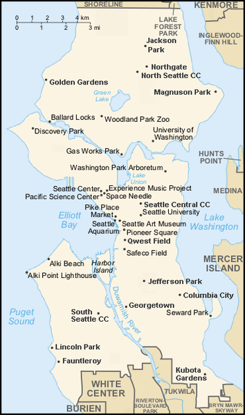
File:Seattle map 2.png
Appearance

Size of this preview: 354 × 600 pixels. Other resolutions: 141 × 240 pixels | 370 × 627 pixels.
Original file (370 × 627 pixels, file size: 89 KB, MIME type: image/png)
File history
Click on a date/time to view the file as it appeared at that time.
| Date/Time | Thumbnail | Dimensions | User | Comment | |
|---|---|---|---|---|---|
| current | 03:37, 21 March 2008 |  | 370 × 627 (89 KB) | Jmabel | corrected spelling of "Magnuson" |
| 07:03, 20 December 2007 |  | 370 × 627 (91 KB) | Jmabel | {{Information |Description=Map of Seattle. Based on map created by ShadowDragon, which was in turn based on maps from the U.S. Census Bureau's website and the CIA World Factbook's map style. More places labeled (mostly |
File usage
The following 11 pages use this file:
- Bikur Cholim Machzikay Hadath
- Congregation Ezra Bessaroth
- Dockside Cannabis Museum
- Kavana Cooperative
- Langston Hughes Performing Arts Institute
- Magnuson Park
- Matthews Beach Park
- Statue of Lenin (Seattle)
- Talk:Seattle/Archive 6
- Module:Location map/data/Seattle landmarks
- Module:Location map/data/Seattle landmarks/doc
Global file usage
The following other wikis use this file:
- Usage on es.wikipedia.org
- Usage on ja.wikipedia.org
- Usage on si.wikipedia.org
- Usage on uz.wikipedia.org

