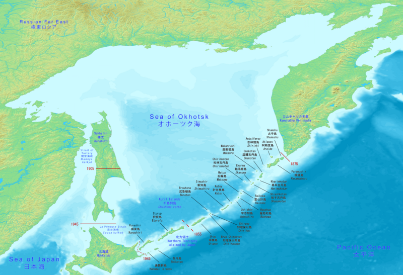
File:Sea-of-Okhotsk-Full-Map-Hokkaido-Kuril-Kamchatka-Sakhalin.png
Appearance

Size of this preview: 800 × 547 pixels. Other resolutions: 320 × 219 pixels | 640 × 438 pixels | 1,024 × 700 pixels | 1,280 × 875 pixels | 2,560 × 1,751 pixels | 5,188 × 3,548 pixels.
Original file (5,188 × 3,548 pixels, file size: 14.83 MB, MIME type: image/png)
File history
Click on a date/time to view the file as it appeared at that time.
| Date/Time | Thumbnail | Dimensions | User | Comment | |
|---|---|---|---|---|---|
| current | 15:10, 17 June 2020 |  | 5,188 × 3,548 (14.83 MB) | Artanisen | Corrected Japanese spelling: オホーツク海 |
| 00:37, 17 June 2020 |  | 5,188 × 3,548 (14.83 MB) | Artanisen | Fixed letter font of Shumshu. | |
| 16:44, 16 June 2020 |  | 5,188 × 3,548 (14.83 MB) | Artanisen | Updated to show the full Sea of Okhotsk with a big detailed map. It includes the Japanese and Russian names with standard English translations. | |
| 21:00, 13 June 2020 |  | 3,280 × 2,144 (2.24 MB) | Artanisen | Uploaded a work by DEMIS World Map Server, Artanisen from https://www.demis.nl/products/web-map-server/examples with UploadWizard |
File usage
The following 3 pages use this file:
Global file usage
The following other wikis use this file:
- Usage on ca.wikipedia.org
- Usage on ky.wikipedia.org
- Usage on sl.wikipedia.org
- Usage on sr.wikipedia.org

