Jump to content

File:Schoenbrunn Tract.png

Page contents not supported in other languages.
This is a file from the Wikimedia Commons
From Wikipedia, the free encyclopedia

Original file (487 × 738 pixels, file size: 78 KB, MIME type: image/png)

Summary

Description
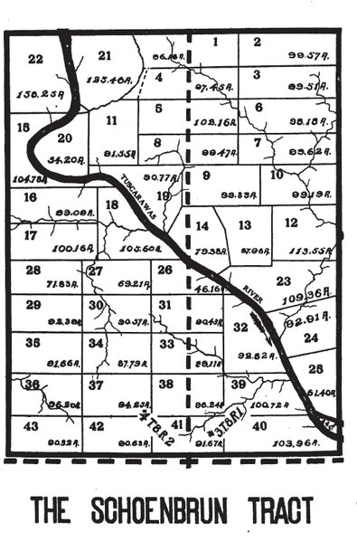
English: A map of a tract of land in Tuscarawas County, Ohio set aside for Christian Munsee in the 18th century. see Moravian Indian Grants
Date
Source Peters, William E (1918) Ohio Lands and Their Subdivision, W.E. Peters, p. 206
Author William Peters
Camera location40° 27′ 25″ N, 81° 25′ 20″ W Kartographer map based on OpenStreetMap.View this and other nearby images on: OpenStreetMapinfo

Licensing

Public domain
This work is in the public domain in the United States because it was published (or registered with the U.S. Copyright Office) before January 1, 1929.

Public domain works must be out of copyright in both the United States and in the source country of the work in order to be hosted on the Commons. If the work is not a U.S. work, the file must have an additional copyright tag indicating the copyright status in the source country.
Note: This tag should not be used for sound recordings.PD-1923Public domain in the United States//commons.wikimedia.org/wiki/File:Schoenbrunn_Tract.png

Captions

Add a one-line explanation of what this file represents

Items portrayed in this file

depicts

40°27'24.998"N, 81°25'19.999"W

79,507 byte

738 pixel

487 pixel

image/png

7bcefa0fd7b34548f439d2fb8e03fae3d29c666b

File history

Click on a date/time to view the file as it appeared at that time.

Date/TimeThumbnailDimensionsUserComment
current21:51, 17 October 2014Thumbnail for version as of 21:51, 17 October 2014487 × 738 (78 KB)Roseohioresident{{Information |Description ={{en|1=A map of a tract of land in {{w|Tuscarawas County,Ohio}} set aside for {{w|Christian Munsee}} in the 18th century. see {{w|Moravian Indian Grants}}}} |Source ={{cite book |title=Ohio Lands and Their Subdiv...

The following page uses this file:

Metadata