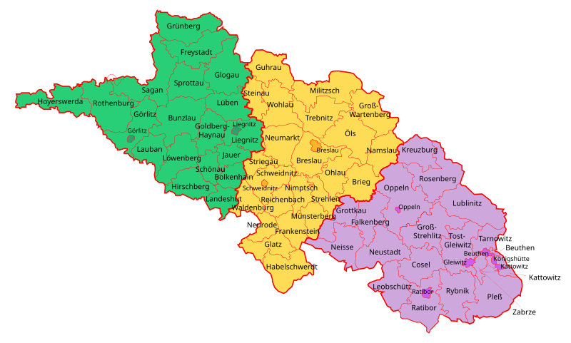
File:Schlesien Verwaltungsgliederung 1905.svg
Appearance

Size of this PNG preview of this SVG file: 800 × 480 pixels. Other resolutions: 320 × 192 pixels | 1,024 × 614 pixels | 1,280 × 767 pixels | 2,560 × 1,535 pixels | 1,091 × 654 pixels.
Original file (SVG file, nominally 1,091 × 654 pixels, file size: 139 KB)
File history
Click on a date/time to view the file as it appeared at that time.
| Date/Time | Thumbnail | Dimensions | User | Comment | |
|---|---|---|---|---|---|
| current | 15:56, 3 April 2015 |  | 1,091 × 654 (139 KB) | Furfur | Fehler im Landkreis Oppeln beseitigt, + Stadtkreis Ratibor (seit 1903), svg etwas aufgeräumt |
| 17:26, 16 March 2015 |  | 1,091 × 654 (126 KB) | Furfur | Grottau -> Grottkau | |
| 01:26, 12 April 2014 |  | 1,091 × 654 (126 KB) | Furfur | Bildkosmetik | |
| 01:20, 12 April 2014 |  | 1,091 × 654 (126 KB) | Furfur | {{Information |Description={{de|1=Verwaltungsgliederung der Provinz Schlesien im Jahr 1905: {{legend|#29CF77|Regierungsbezirk Liegnitz}} {{legend|#FFDC56|Regierungsbezirk Breslau}} {{legend|#CEA7DD|Regierungsbezirk Oppeln}}}} {{en|1=Administrative divi... |
File usage
The following 4 pages use this file:
Global file usage
The following other wikis use this file:
- Usage on be.wikipedia.org
- Usage on cs.wikipedia.org
- Usage on de.wikipedia.org
- Usage on fr.wikipedia.org
- Usage on lt.wikipedia.org
- Usage on pl.wikipedia.org
- Usage on ru.wikipedia.org
- Usage on sv.wikipedia.org
- Usage on szl.wikipedia.org
- Usage on zh.wikipedia.org

