File:Saltholm-oresund.png
Appearance
Saltholm-oresund.png (431 × 232 pixels, file size: 37 KB, MIME type: image/png)
File history
Click on a date/time to view the file as it appeared at that time.
| Date/Time | Thumbnail | Dimensions | User | Comment | |
|---|---|---|---|---|---|
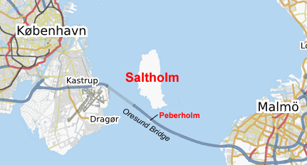
| current | 17:19, 14 January 2009 |  | 431 × 232 (37 KB) | ChrisO | {{Information |Description={{en|1=Map of the southern Øresund showing the locations of Saltholm and Peberholm islands. Generated from http://www.openstreetmap.org/}} |Source=OpenStreetMap |Author=OpenStreetMap community |Date=2009-01-14 |Permission={{cc- |
File usage
Global file usage
The following other wikis use this file:
- Usage on da.wikipedia.org
- Usage on el.wikipedia.org
- Usage on es.wikipedia.org
- Usage on et.wikipedia.org
- Usage on hu.wikipedia.org
- Usage on is.wikipedia.org
- Usage on ka.wikipedia.org
- Usage on nl.wikipedia.org
- Usage on pt.wikipedia.org
- Usage on ru.wikipedia.org

