Jump to content

File:SFOBB map.svg

Page contents not supported in other languages.
This is a file from the Wikimedia Commons
From Wikipedia, the free encyclopedia

Original file (SVG file, nominally 512 × 355 pixels, file size: 314 KB)

A raster version of this image is available. It should be used in place of this vector image when superior.
File:SFOBB map.svgFile:SFOBB map de.png

In general, it is better to use a good SVG version.


Bitmap image
A raster version of this image is available. It should be used in place of this vector image when superior.
File:SFOBB map.svgFile:SFOBB map en.png

In general, it is better to use a good SVG version.


Bitmap image

Summary

Description
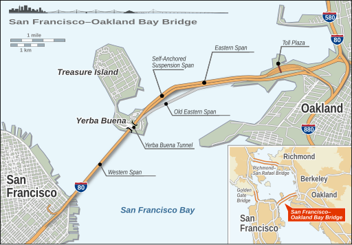
Deutsch: Übersichtsplan der San Francisco-Oakland Bay Bridge mit dem geplanten Neubau der östlichen Querung.
English: San Francisco-Oakland Bay Bridge layout map including proposed eastern span replacement
Date
Source Own work
Author Alexrk2
Other versions

[edit]
San Francisco-Oakland Bay Bridge

SVG development
InfoField
 
The SVG code is valid.
 
This map was created with Inkscape.

Licensing

I, the copyright holder of this work, hereby publish it under the following license:
w:en:Creative Commons
attribution
This file is licensed under the Creative Commons Attribution 3.0 Unported license.
You are free:
  • to share – to copy, distribute and transmit the work
  • to remix – to adapt the work
Under the following conditions:
  • attribution – You must give appropriate credit, provide a link to the license, and indicate if changes were made. You may do so in any reasonable manner, but not in any way that suggests the licensor endorses you or your use.

Captions

Add a one-line explanation of what this file represents

Items portrayed in this file

depicts

October 2013

File history

Click on a date/time to view the file as it appeared at that time.

(newest | oldest) View (newer 10 | ) (10 | 20 | 50 | 100 | 250 | 500)
Date/TimeThumbnailDimensionsUserComment
current15:17, 25 December 2017Thumbnail for version as of 15:17, 25 December 2017512 × 355 (314 KB)JoKalliauerProper languageswitch de and en
12:09, 4 October 2013Thumbnail for version as of 12:09, 4 October 2013595 × 413 (461 KB)Alexrk2Eastern span opened in 9/2013
14:45, 19 March 2009Thumbnail for version as of 14:45, 19 March 2009595 × 413 (812 KB)KmusserApplied Dschwen's fixes to "en" layer as well
15:05, 18 March 2009Thumbnail for version as of 15:05, 18 March 2009595 × 413 (826 KB)Kmusseradded corrections that were made on English PNG version
19:21, 16 October 2008Thumbnail for version as of 19:21, 16 October 2008595 × 413 (826 KB)Dschwenfix broken fonts in highway shields on "de" layer
19:12, 16 October 2008Thumbnail for version as of 19:12, 16 October 2008595 × 413 (826 KB)Dschwencenter "Oakland" label in "de" layer
19:01, 16 October 2008Thumbnail for version as of 19:01, 16 October 2008595 × 413 (826 KB)DschwenReverted to version as of 09:37, 8 October 2008 to test SVG render
17:09, 10 October 2008Thumbnail for version as of 17:09, 10 October 2008595 × 413 (819 KB)Alexrkwatermark
16:48, 10 October 2008Thumbnail for version as of 16:48, 10 October 2008595 × 413 (817 KB)Alexrkpush German label layer down below background
09:37, 8 October 2008Thumbnail for version as of 09:37, 8 October 2008595 × 413 (826 KB)Alexrk
(newest | oldest) View (newer 10 | ) (10 | 20 | 50 | 100 | 250 | 500)

The following page uses this file:

Metadata