From Wikipedia, the free encyclopedia
No higher resolution available.
Summary
Licensing
Public domain Public domain false false
This work has been released into the public domain Kinori , at the Japanese Wikipedia projectIn case this is not legally possible: Kinori grants anyone the right to use this work for any purpose , without any conditions, unless such conditions are required by law.
Original upload log
This file was moved from Japanese Wikipedia .
See below for original file information.
File name
SouseiKawa2004-4.jpg
Description
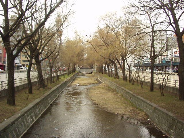
[[創成川]]の中流 *撮影位置: 北海道、札幌市、[[中央区 (札幌市)|中央区]]。南三条通の橋から北向き。 *撮影日: 2004年4月11日。 *撮影者: Kinori (投稿者と同じ)。 *画像形式: JPEG形式、640x480ピクセル、色数24bit。 *川の両側の道路は創成川通。中央左の背景に見えるのは、大通公園にある[[さっぽろテレビ塔]]である。 {{PD-self}}
File history
Date/Time (UTC)
Dimensions
User
Comment
11 April 2004, 21:58:34
640x480
Kinori 創成川の中流
Page history
Date/Time (UTC)
Flag
User
Edit summary :
11 April 2004, 21:58:34
Kinori 創成川の中流
11 April 2004, 22:04:35
Kinori
16 October 2004, 13:44:28
m
Kinori PD
16 March 2007, 13:25:27
m
K. Takeda +カテゴリ
14 April 2007, 01:39:32
m
満月
5 May 2007, 01:18:24
m
満月
13 July 2008, 09:44:21
m
Deapy
31 December 2013, 07:38:30
m
KASEI [[Category:中央区 (札幌市)の画像]]を除去; [[Category:札幌市中央区の画像]]を追加 ([[WP:HotCat|HotCat]]使用)
Deutsch ∙ English ∙ فارسی ∙ 日本語 ∙ 한국어 ∙ македонски ∙ +/−
English Add a one-line explanation of what this file represents
File history
Click on a date/time to view the file as it appeared at that time.
Date/Time Thumbnail Dimensions User Comment current 05:28, 11 October 2014 640 × 480 (93 KB) Mr. Stradivarius User created page with UploadWizard
File usage
The following 2 pages use this file:
Global file usage
The following other wikis use this file:
Usage on ja.wikipedia.org
Usage on ko.wikipedia.org
This file contains additional information, probably added from the digital camera or scanner used to create or digitize it.
If the file has been modified from its original state, some details may not fully reflect the modified file.


