Jump to content

File:Rita 2005-09-18 1540Z.jpg

Page contents not supported in other languages.
This is a file from the Wikimedia Commons
From Wikipedia, the free encyclopedia

Original file (6,000 × 4,500 pixels, file size: 4.75 MB, MIME type: image/jpeg)

Summary

Description

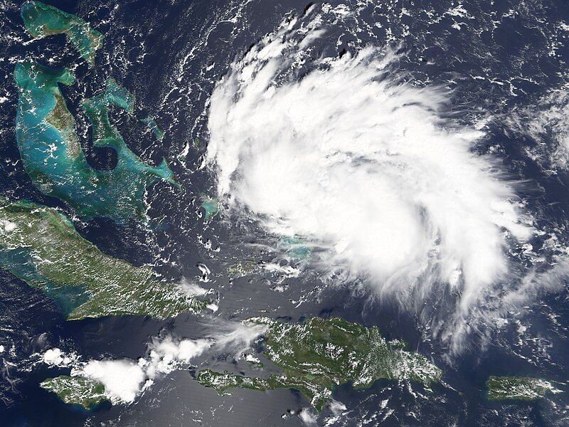
A tropical depression formed in the Bahamas on September 17, 2005. Once it was organized enough to have winds of over 62 kilometers per hour (39 miles per hour), it was classified as a tropical storm and given the name Rita, becoming the 17th named storm system of the 2005 hurricane season. With the season not yet over, 2005 is already the 5th most active storm season since naming records were started in 1851. According to the National Hurricane Center, 21 tropical storms formed in 1933, 19 developed in 1995 and 1887, and 18 formed in 1969. Rita is also the earliest “R” named storm in a season.

Rita crossed the threshold to tropical storm status around 5:00 p.m. (local time) on September 18, 2005. The Moderate Resolution Imaging Spectroradiometer (MODIS) on NASA’s Terra satellite captured this image of Rita roughly fives hours earlier at 11:40 a.m. while the storm was still an organizing tropical depression. The classical spiral structure of a hurricane is not yet fully formed, nor is there a well-organized eye of the storm, but these nascent features of the developing system are apparent already.

Forecasters are particularly concerned about Rita as it is projected to pass through the Florida Key Islands as it reaches hurricane strength. The storm track projections as of September 19 have it crossing the Gulf of Mexico to make landfall in the general vicinity of southern Texas, but forecasting hurricanes several days in advance is still an uncertain science and there are fears that Rita could turn in the Gulf and head into areas recently battered by Katrina.
Date
Source http://earthobservatory.nasa.gov/NaturalHazards/natural_hazards_v2.php3?img_id=13139
Author NASA image created by Jesse Allen, Earth Observatory, using data obtained courtesy of the MODIS Rapid Response team.
Permission
(Reusing this file)
Public domain This file is in the public domain in the United States because it was solely created by NASA. NASA copyright policy states that "NASA material is not protected by copyright unless noted". (See Template:PD-USGov, NASA copyright policy page or JPL Image Use Policy.)
Warnings:

Captions

Add a one-line explanation of what this file represents

Items portrayed in this file

depicts

18 September 2005

image/jpeg

File history

Click on a date/time to view the file as it appeared at that time.

Date/TimeThumbnailDimensionsUserComment
current03:03, 3 November 2006Thumbnail for version as of 03:03, 3 November 20066,000 × 4,500 (4.75 MB)Good kitty== Summary == {{Information |Description=A tropical depression formed in the Bahamas on September 17, 2005. Once it was organized enough to have winds of over 62 kilometers per hour (39 miles per hour), it was classified as a tropical storm and given the

The following 2 pages use this file:

Global file usage

The following other wikis use this file:

Metadata