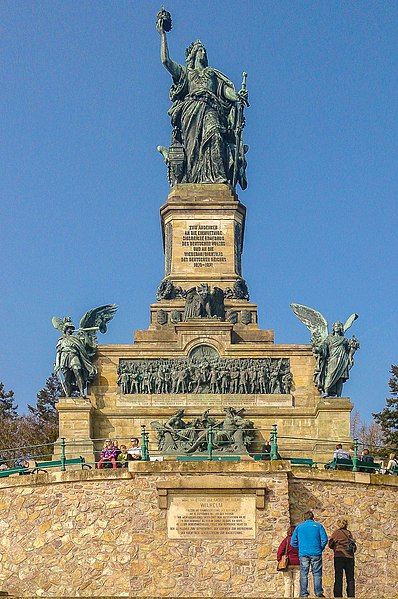
File:RÜD-140308-001.jpg

Original file (1,828 × 2,750 pixels, file size: 6.41 MB, MIME type: image/jpeg)
| This is a file from the Wikimedia Commons. Information from its description page there is shown below. Commons is a freely licensed media file repository. You can help. |
Summary
| Karl Weißbach: Niederwalddenkmal
|
|||||||||||||||||||||||||||||||||||||||||||||||
|---|---|---|---|---|---|---|---|---|---|---|---|---|---|---|---|---|---|---|---|---|---|---|---|---|---|---|---|---|---|---|---|---|---|---|---|---|---|---|---|---|---|---|---|---|---|---|---|
| Artist |
|
||||||||||||||||||||||||||||||||||||||||||||||
| Architect |
|
||||||||||||||||||||||||||||||||||||||||||||||
| Title |
Niederwalddenkmal label QS:Lit,"Niederwalddenkmal"
label QS:Lfr,"Niederwalddenkmal"
label QS:Lde,"Niederwalddenkmal"
label QS:Lvi,"Đài tưởng niệm Niederwald"
label QS:Lzh,"下瓦尔德纪念碑"
label QS:Lda,"Niederwalddenkmal"
label QS:Ltr,"Niederwald anıtı"
label QS:Lja,"ニーダーヴァルト記念碑"
label QS:Lid,"Niederwalddenkmal"
label QS:Lhe,"אנדרטת נידרוואלד"
label QS:Lnb,"Niederwalddenkmal"
label QS:Lnl,"Niederwalddenkmal"
label QS:Lzh-hant,"下瓦爾德紀念碑"
label QS:Lzh-cn,"下瓦尔德纪念碑"
label QS:Lsv,"Niederwalddenkmal"
label QS:Lceb,"Niederwald (lasang sa Alemanya, Hessen, lat 49,98, long 7,90)"
label QS:Len,"Niederwalddenkmal"
label QS:Leo,"Niederwalddenkmal"
label QS:Lzh-hans,"下瓦尔德纪念碑"
label QS:Lru,"Памятник Нидервальд" |
||||||||||||||||||||||||||||||||||||||||||||||
| Part of |
Rhine Gorge |
||||||||||||||||||||||||||||||||||||||||||||||
| Object type |
monument / war memorial |
||||||||||||||||||||||||||||||||||||||||||||||
| Date |
1883 |
||||||||||||||||||||||||||||||||||||||||||||||
| Medium |
bronze and stone |
||||||||||||||||||||||||||||||||||||||||||||||
| Dimensions |
height: 12.5 m (13.6 yd) dimensions QS:P2048,+12.5U11573 |
||||||||||||||||||||||||||||||||||||||||||||||
| Object location |
|
||||||||||||||||||||||||||||||||||||||||||||||
| Inscriptions |
|
||||||||||||||||||||||||||||||||||||||||||||||
| References | |||||||||||||||||||||||||||||||||||||||||||||||
| Authority file | |||||||||||||||||||||||||||||||||||||||||||||||
| Source/Photographer | Self-photographed by Bytfisch, 8 March 2014 | ||||||||||||||||||||||||||||||||||||||||||||||
| Other versions |
|
||||||||||||||||||||||||||||||||||||||||||||||
| Camera location | 49° 58′ 51.3″ N, 7° 53′ 59.87″ E | View this and other nearby images on: OpenStreetMap |
|---|
Licensing
- Object
-
Public domainPublic domainfalsefalse
https://creativecommons.org/publicdomain/mark/1.0/PDMCreative Commons Public Domain Mark 1.0falsefalse
The author died in 1910, so this work is in the public domain in its country of origin and other countries and areas where the copyright term is the author's life plus 100 years or fewer.
This work is in the public domain in the United States because it was published (or registered with the U.S. Copyright Office) before January 1, 1929.
This file has been identified as being free of known restrictions under copyright law, including all related and neighboring rights. - Photograph
- Bytfisch, the copyright holder of this work, hereby publishes it under the following license:


 This file is licensed under the Creative Commons Attribution-Share Alike 4.0 International license.Attribution: Bytfischhttps://creativecommons.org/licenses/by-sa/4.0CC BY-SA 4.0 Creative Commons Attribution-Share Alike 4.0 truetrue
- You are free:
- to share – to copy, distribute and transmit the work
- to remix – to adapt the work
- Under the following conditions:
- attribution – You must give appropriate credit, provide a link to the license, and indicate if changes were made. You may do so in any reasonable manner, but not in any way that suggests the licensor endorses you or your use.
- share alike – If you remix, transform, or build upon the material, you must distribute your contributions under the same or compatible license as the original.
- You are free:
Captions
Items portrayed in this file
depicts
49°58'51.298"N, 7°53'59.870"E
49°58'51.701"N, 7°53'59.399"E
0.0008 second
2.4
4.1 millimetre
image/jpeg
File history
Click on a date/time to view the file as it appeared at that time.
| Date/Time | Thumbnail | Dimensions | User | Comment | |
|---|---|---|---|---|---|
| current | 20:49, 10 November 2014 |  | 1,828 × 2,750 (6.41 MB) | Bytfisch | User created page with UploadWizard |
File usage
The following page uses this file:
Global file usage
The following other wikis use this file:
- Usage on de.wikipedia.org
- Usage on de.wikivoyage.org
- Usage on eo.wikipedia.org
- Usage on he.wikipedia.org
- Usage on id.wikipedia.org
- Usage on it.wikipedia.org
- Usage on vi.wikipedia.org
- Usage on www.wikidata.org
Metadata
This file contains additional information, probably added from the digital camera or scanner used to create or digitize it.
If the file has been modified from its original state, some details may not fully reflect the modified file.
| Camera manufacturer | SONY |
|---|---|
| Camera model | C6603 |
| Exposure time | 1/1,250 sec (0.0008) |
| F-number | f/2.4 |
| ISO speed rating | 40 |
| Date and time of data generation | 13:39, 8 March 2014 |
| Lens focal length | 4.1 mm |
| Latitude | 49° 58′ 51.3″ N |
| Longitude | 7° 53′ 59.87″ E |
| Width | 2,204 px |
| Height | 3,920 px |
| Bits per component |
|
| Pixel composition | RGB |
| Orientation | Normal |
| Number of components | 3 |
| Horizontal resolution | 72 dpi |
| Vertical resolution | 72 dpi |
| Software used | Adobe Photoshop CC (Windows) |
| File change date and time | 13:39, 8 March 2014 |
| Y and C positioning | Centered |
| Exif version | 2.2 |
| Date and time of digitizing | 13:39, 8 March 2014 |
| Meaning of each component |
|
| Shutter speed | 10.28 |
| APEX aperture | 2.526069 |
| Exposure bias | 0 |
| Metering mode | Center weighted average |
| Light source | Unknown |
| Flash | Flash did not fire, auto mode |
| Supported Flashpix version | 1 |
| Color space | sRGB |
| Custom image processing | Normal process |
| Exposure mode | Auto exposure |
| White balance | Auto white balance |
| Digital zoom ratio | 1 |
| Scene capture type | Landscape |
| Subject distance range | Unknown |
| GPS time (atomic clock) | 13:39 |
| Geodetic survey data used | WGS-84 |
| GPS date | 8 March 2014 |
| GPS tag version | 2.2.0.0 |
| Date metadata was last modified | 14:38, 8 November 2014 |
| Unique ID of original document | 462424BC7DD53689F174C0BDC8B6D204 |
| IIM version | 47 |


