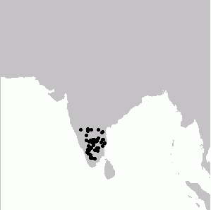
File:PycnonotusXantholaemusMap.png
Appearance
PycnonotusXantholaemusMap.png (299 × 297 pixels, file size: 1 KB, MIME type: image/png)
File history
Click on a date/time to view the file as it appeared at that time.
| Date/Time | Thumbnail | Dimensions | User | Comment | |
|---|---|---|---|---|---|
| current | 14:59, 22 August 2009 |  | 299 × 297 (1 KB) | Shyamal | Remove southern most point, which appears not to be accepted |
| 15:51, 10 November 2008 |  | 299 × 297 (1 KB) | Shyamal | {{Information |Description={{en|1=Distribution map of Pycnonotus xantholaemus generated by BirdSpot 3.6}} |Source=Own work by uploader |Author=Shyamal |Date=November 2008 |Permission= |other_versions= }} <!--{{ImageUpload|full}}--> [[Cat |
File usage
The following page uses this file:
Global file usage
The following other wikis use this file:
- Usage on ar.wikipedia.org
- Usage on arz.wikipedia.org
- Usage on ast.wikipedia.org
- Usage on bg.wikipedia.org
- Usage on ca.wikipedia.org
- Usage on ceb.wikipedia.org
- Usage on cy.wikipedia.org
- Usage on de.wikipedia.org
- Usage on es.wikipedia.org
- Usage on eu.wikipedia.org
- Usage on kn.wikipedia.org
- Usage on ml.wikipedia.org
- Usage on nv.wikipedia.org
- Usage on pl.wikipedia.org
- Usage on sv.wikipedia.org
- Usage on ta.wikipedia.org
- Usage on vi.wikipedia.org
- Usage on www.wikidata.org

